 https://www.mountainmoments.com/wp-content/uploads/2022/02/Hochfelln-Hiking-Route-Map-Mountain-Moments-Photography-Workshop-Gallery-2.jpeg
1333
2000
Marius
https://www.mountainmoments.com/wp-content/uploads/2023/07/MM_Logo_180-width.png
Marius2023-03-12 15:06:002023-03-11 15:55:55Hochfelln Hike! Astonishing scenic views at Hochfelln Hut in the Chiemgau Alps + all infos
https://www.mountainmoments.com/wp-content/uploads/2022/02/Hochfelln-Hiking-Route-Map-Mountain-Moments-Photography-Workshop-Gallery-2.jpeg
1333
2000
Marius
https://www.mountainmoments.com/wp-content/uploads/2023/07/MM_Logo_180-width.png
Marius2023-03-12 15:06:002023-03-11 15:55:55Hochfelln Hike! Astonishing scenic views at Hochfelln Hut in the Chiemgau Alps + all infos https://www.mountainmoments.com/wp-content/uploads/2022/02/Hochgern-Hiking-Route-Map-Mountain-Moments-Photography-Workshops-2.jpeg
1333
2000
Marius
https://www.mountainmoments.com/wp-content/uploads/2023/07/MM_Logo_180-width.png
Marius2023-03-11 14:32:522023-03-11 14:33:03Reach the Hochgern Summit! Scenic hike in the Chiemgau Alps – Infos, Tips and Map
https://www.mountainmoments.com/wp-content/uploads/2022/02/Hochgern-Hiking-Route-Map-Mountain-Moments-Photography-Workshops-2.jpeg
1333
2000
Marius
https://www.mountainmoments.com/wp-content/uploads/2023/07/MM_Logo_180-width.png
Marius2023-03-11 14:32:522023-03-11 14:33:03Reach the Hochgern Summit! Scenic hike in the Chiemgau Alps – Infos, Tips and Map https://www.mountainmoments.com/wp-content/uploads/2022/02/Kampenwand-Hiking-Route-Mountain-Moments-Photography-Workshop-Gallery-1.jpeg
1333
2000
Marius
https://www.mountainmoments.com/wp-content/uploads/2023/07/MM_Logo_180-width.png
Marius2023-03-11 14:00:012023-03-16 16:06:28Kampenwand Hike! Easy hike for families and photrographers alike! Photograph Jagged Rock Ridges
https://www.mountainmoments.com/wp-content/uploads/2022/02/Kampenwand-Hiking-Route-Mountain-Moments-Photography-Workshop-Gallery-1.jpeg
1333
2000
Marius
https://www.mountainmoments.com/wp-content/uploads/2023/07/MM_Logo_180-width.png
Marius2023-03-11 14:00:012023-03-16 16:06:28Kampenwand Hike! Easy hike for families and photrographers alike! Photograph Jagged Rock Ridges https://www.mountainmoments.com/wp-content/uploads/2022/02/Malerwinkel-Hiking-Route-Map-Mountain-Moments-Photography-Workshops-Gallery-Main-2.jpeg
1334
2000
Marius
https://www.mountainmoments.com/wp-content/uploads/2023/07/MM_Logo_180-width.png
Marius2023-03-10 19:41:122023-03-11 12:16:56The most beautiful hike at Königsee (Lake König) – Insta spot Malerwinkel and Rabenwand.
https://www.mountainmoments.com/wp-content/uploads/2022/02/Malerwinkel-Hiking-Route-Map-Mountain-Moments-Photography-Workshops-Gallery-Main-2.jpeg
1334
2000
Marius
https://www.mountainmoments.com/wp-content/uploads/2023/07/MM_Logo_180-width.png
Marius2023-03-10 19:41:122023-03-11 12:16:56The most beautiful hike at Königsee (Lake König) – Insta spot Malerwinkel and Rabenwand. https://www.mountainmoments.com/wp-content/uploads/2022/02/Kehlsteinhaus-Rossfeld-Panoramastrasse-Hiking-Route-Map-Mountain-Moments-Gallery-3.jpeg
1800
1350
Marius
https://www.mountainmoments.com/wp-content/uploads/2023/07/MM_Logo_180-width.png
Marius2023-03-10 19:29:062023-03-11 15:55:34Hiking to Kehlstein House! Panoramic Photography as Rossfeld Scenic Road and Dark History of the “Eagle’s Nest”
https://www.mountainmoments.com/wp-content/uploads/2022/02/Kehlsteinhaus-Rossfeld-Panoramastrasse-Hiking-Route-Map-Mountain-Moments-Gallery-3.jpeg
1800
1350
Marius
https://www.mountainmoments.com/wp-content/uploads/2023/07/MM_Logo_180-width.png
Marius2023-03-10 19:29:062023-03-11 15:55:34Hiking to Kehlstein House! Panoramic Photography as Rossfeld Scenic Road and Dark History of the “Eagle’s Nest” https://www.mountainmoments.com/wp-content/uploads/2022/07/Hochgrat-Allgaeu-Alps-and-the-Nagelfluhkette-Nature-Park-Main.jpg
1333
2000
Marius
https://www.mountainmoments.com/wp-content/uploads/2023/07/MM_Logo_180-width.png
Marius2022-07-31 14:58:512022-08-03 09:07:05TOP-5 Prime Telephoto Locations in German Alps and How to Get There (+ Bonus Tips)
https://www.mountainmoments.com/wp-content/uploads/2022/07/Hochgrat-Allgaeu-Alps-and-the-Nagelfluhkette-Nature-Park-Main.jpg
1333
2000
Marius
https://www.mountainmoments.com/wp-content/uploads/2023/07/MM_Logo_180-width.png
Marius2022-07-31 14:58:512022-08-03 09:07:05TOP-5 Prime Telephoto Locations in German Alps and How to Get There (+ Bonus Tips) https://www.mountainmoments.com/wp-content/uploads/2022/07/Top-10-Photographs-German-Alps-4.jpg
672
1200
Marius
https://www.mountainmoments.com/wp-content/uploads/2023/07/MM_Logo_180-width.png
Marius2022-07-27 09:05:392022-08-03 07:21:28TOP-5 Prettiest Images From German Alps – & Where YOU Can Take Them
https://www.mountainmoments.com/wp-content/uploads/2022/07/Top-10-Photographs-German-Alps-4.jpg
672
1200
Marius
https://www.mountainmoments.com/wp-content/uploads/2023/07/MM_Logo_180-width.png
Marius2022-07-27 09:05:392022-08-03 07:21:28TOP-5 Prettiest Images From German Alps – & Where YOU Can Take Them https://www.mountainmoments.com/wp-content/uploads/2022/02/Kneefelspitze-Hiking-Route-Map-Mountain-Moments-Photography-Workshops-Gallery-1.jpeg
1061
1600
Marius
https://www.mountainmoments.com/wp-content/uploads/2023/07/MM_Logo_180-width.png
Marius2022-03-13 16:18:002023-03-16 14:45:44Scenic Hike on Picturesque Kneifelspitze – A great view in Berchtesgaden
https://www.mountainmoments.com/wp-content/uploads/2022/02/Kneefelspitze-Hiking-Route-Map-Mountain-Moments-Photography-Workshops-Gallery-1.jpeg
1061
1600
Marius
https://www.mountainmoments.com/wp-content/uploads/2023/07/MM_Logo_180-width.png
Marius2022-03-13 16:18:002023-03-16 14:45:44Scenic Hike on Picturesque Kneifelspitze – A great view in Berchtesgaden https://www.mountainmoments.com/wp-content/uploads/2022/02/Kochelsee-Route-Hiking-Map-Mountain-Moments-Photography-Workshops-Gallery-3.jpeg
1800
1440
Marius
https://www.mountainmoments.com/wp-content/uploads/2023/07/MM_Logo_180-width.png
Marius2022-02-16 23:06:002023-03-17 16:49:28Easy Hiking Trail at Lake Kochel! Take Amazing Photos at the Edge of the Bavarian Alps
https://www.mountainmoments.com/wp-content/uploads/2022/02/Kochelsee-Route-Hiking-Map-Mountain-Moments-Photography-Workshops-Gallery-3.jpeg
1800
1440
Marius
https://www.mountainmoments.com/wp-content/uploads/2023/07/MM_Logo_180-width.png
Marius2022-02-16 23:06:002023-03-17 16:49:28Easy Hiking Trail at Lake Kochel! Take Amazing Photos at the Edge of the Bavarian Alps https://www.mountainmoments.com/wp-content/uploads/2022/02/Partnachklamm-Route-Map-Mountain-Moments-HIking-and-Photography-Tips-Gallery-2.jpeg
1800
1440
Marius
https://www.mountainmoments.com/wp-content/uploads/2023/07/MM_Logo_180-width.png
Marius2022-02-16 22:06:002023-03-17 16:50:02Partnach Gorge Waterfalls! Hiking Map and Photo Tips for Nature Enthusiasts
https://www.mountainmoments.com/wp-content/uploads/2022/02/Partnachklamm-Route-Map-Mountain-Moments-HIking-and-Photography-Tips-Gallery-2.jpeg
1800
1440
Marius
https://www.mountainmoments.com/wp-content/uploads/2023/07/MM_Logo_180-width.png
Marius2022-02-16 22:06:002023-03-17 16:50:02Partnach Gorge Waterfalls! Hiking Map and Photo Tips for Nature Enthusiasts https://www.mountainmoments.com/wp-content/uploads/2021/07/Mountain-Moments-Mountaineering-Klettersteig-Kalkkoegel-Hiking-Nature-Photography-Main.jpeg
1335
2000
Marius
https://www.mountainmoments.com/wp-content/uploads/2023/07/MM_Logo_180-width.png
Marius2021-10-01 10:49:182021-10-28 21:20:21Kalkkögel Via Ferrata – Meet “Little Brenta of Tyrol” on 13.5km Hike
https://www.mountainmoments.com/wp-content/uploads/2021/07/Mountain-Moments-Mountaineering-Klettersteig-Kalkkoegel-Hiking-Nature-Photography-Main.jpeg
1335
2000
Marius
https://www.mountainmoments.com/wp-content/uploads/2023/07/MM_Logo_180-width.png
Marius2021-10-01 10:49:182021-10-28 21:20:21Kalkkögel Via Ferrata – Meet “Little Brenta of Tyrol” on 13.5km Hike https://www.mountainmoments.com/wp-content/uploads/2021/07/Mountain-Moments-Climbing-Kletterlocations-Route-Photography-Main.jpeg
1333
2000
Marius
https://www.mountainmoments.com/wp-content/uploads/2023/07/MM_Logo_180-width.png
Marius2021-09-25 16:30:422023-03-31 15:27:36Innsbruck Rock Climbing Guide – Gardens and Boulder Spots close to the City Center
https://www.mountainmoments.com/wp-content/uploads/2021/07/Mountain-Moments-Climbing-Kletterlocations-Route-Photography-Main.jpeg
1333
2000
Marius
https://www.mountainmoments.com/wp-content/uploads/2023/07/MM_Logo_180-width.png
Marius2021-09-25 16:30:422023-03-31 15:27:36Innsbruck Rock Climbing Guide – Gardens and Boulder Spots close to the City Center https://www.mountainmoments.com/wp-content/uploads/2021/07/Mountain-Moments-Innsbruck-Nordkette-Via-Ferrata-Ridge-Photography-8-2.jpeg
1333
2000
Marius
https://www.mountainmoments.com/wp-content/uploads/2023/07/MM_Logo_180-width.png
Marius2021-09-20 20:51:012021-09-20 20:51:12Innsbruck-Nordkette Via Ferrata Ridge Hike – Photo Gallery From the Eastern Alps
https://www.mountainmoments.com/wp-content/uploads/2021/07/Mountain-Moments-Innsbruck-Nordkette-Via-Ferrata-Ridge-Photography-8-2.jpeg
1333
2000
Marius
https://www.mountainmoments.com/wp-content/uploads/2023/07/MM_Logo_180-width.png
Marius2021-09-20 20:51:012021-09-20 20:51:12Innsbruck-Nordkette Via Ferrata Ridge Hike – Photo Gallery From the Eastern Alps https://www.mountainmoments.com/wp-content/uploads/2021/08/web_mountainmoments-8047-2.jpg
1335
2000
Marius
https://www.mountainmoments.com/wp-content/uploads/2023/07/MM_Logo_180-width.png
Marius2021-09-20 12:43:122021-09-20 12:43:26Strolling Through Innsbruck: Top-8 Most Beautiful Walks
https://www.mountainmoments.com/wp-content/uploads/2021/08/web_mountainmoments-8047-2.jpg
1335
2000
Marius
https://www.mountainmoments.com/wp-content/uploads/2023/07/MM_Logo_180-width.png
Marius2021-09-20 12:43:122021-09-20 12:43:26Strolling Through Innsbruck: Top-8 Most Beautiful Walks https://www.mountainmoments.com/wp-content/uploads/2021/08/web_mountainmoments-0792-Viewpoints-Hochiss-and-Rotspitzwand-1.jpg
1333
2000
Marius
https://www.mountainmoments.com/wp-content/uploads/2023/07/MM_Logo_180-width.png
Marius2021-09-17 10:57:342021-09-17 19:12:45Photo Spots Achensee: The 7 Most Beautiful Places and Sights + Hiking Tours
https://www.mountainmoments.com/wp-content/uploads/2021/08/web_mountainmoments-0792-Viewpoints-Hochiss-and-Rotspitzwand-1.jpg
1333
2000
Marius
https://www.mountainmoments.com/wp-content/uploads/2023/07/MM_Logo_180-width.png
Marius2021-09-17 10:57:342021-09-17 19:12:45Photo Spots Achensee: The 7 Most Beautiful Places and Sights + Hiking Tours https://www.mountainmoments.com/wp-content/uploads/2021/06/Mountain-Moments-Friulanische-Dolomiten-Campanile-Hiking-Nature-Photography-Dolomites-Main.jpeg
1333
2000
Marius
https://www.mountainmoments.com/wp-content/uploads/2023/07/MM_Logo_180-width.png
Marius2021-09-02 15:08:352021-09-02 15:10:13A wonderful panoramic Day-Hike to Campanile di Val Montanaia in the Friulan Dolomites – Insider Tips!
https://www.mountainmoments.com/wp-content/uploads/2021/06/Mountain-Moments-Friulanische-Dolomiten-Campanile-Hiking-Nature-Photography-Dolomites-Main.jpeg
1333
2000
Marius
https://www.mountainmoments.com/wp-content/uploads/2023/07/MM_Logo_180-width.png
Marius2021-09-02 15:08:352021-09-02 15:10:13A wonderful panoramic Day-Hike to Campanile di Val Montanaia in the Friulan Dolomites – Insider Tips!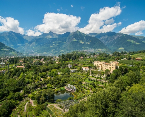 https://www.mountainmoments.com/wp-content/uploads/2021/06/Mountain-Moments-Meran-und-Schloss-Trauttmannsdorff-Hiking-Route-Photograph-Main.jpeg
1335
2000
Marius
https://www.mountainmoments.com/wp-content/uploads/2023/07/MM_Logo_180-width.png
Marius2021-08-31 04:55:532021-08-31 04:56:27Miraculous Merano Hike (easy/2hours) with amazing views – Mountains, Rivers, Vineyards, and Trauttmansdorf Castle!
https://www.mountainmoments.com/wp-content/uploads/2021/06/Mountain-Moments-Meran-und-Schloss-Trauttmannsdorff-Hiking-Route-Photograph-Main.jpeg
1335
2000
Marius
https://www.mountainmoments.com/wp-content/uploads/2023/07/MM_Logo_180-width.png
Marius2021-08-31 04:55:532021-08-31 04:56:27Miraculous Merano Hike (easy/2hours) with amazing views – Mountains, Rivers, Vineyards, and Trauttmansdorf Castle! https://www.mountainmoments.com/wp-content/uploads/2021/06/Mountain-Moments-Rolle-Pass-Pala-Group-Hiking-Route-Wde-Angle-Nature-Photography-Main.jpeg
1220
2000
Marius
https://www.mountainmoments.com/wp-content/uploads/2023/07/MM_Logo_180-width.png
Marius2021-08-20 14:00:212021-08-20 14:00:27Rolle Pass Hiking Trip Mapped Out! Capture the Pala Group Glitter in a Mountain Lake at Baita Segantini
https://www.mountainmoments.com/wp-content/uploads/2021/06/Mountain-Moments-Rolle-Pass-Pala-Group-Hiking-Route-Wde-Angle-Nature-Photography-Main.jpeg
1220
2000
Marius
https://www.mountainmoments.com/wp-content/uploads/2023/07/MM_Logo_180-width.png
Marius2021-08-20 14:00:212021-08-20 14:00:27Rolle Pass Hiking Trip Mapped Out! Capture the Pala Group Glitter in a Mountain Lake at Baita Segantini https://www.mountainmoments.com/wp-content/uploads/2021/06/Mountain-Moments-Pian-di-Cengia-On-Hiking-Route-Map-Photography-Amazing-Main-Image.jpeg
1800
1202
Marius
https://www.mountainmoments.com/wp-content/uploads/2023/07/MM_Logo_180-width.png
Marius2021-08-04 16:48:082021-08-04 16:48:17Pian di Cengia – Quiet Alpine Hiking Paths With Photos That Scream Beauty
https://www.mountainmoments.com/wp-content/uploads/2021/06/Mountain-Moments-Pian-di-Cengia-On-Hiking-Route-Map-Photography-Amazing-Main-Image.jpeg
1800
1202
Marius
https://www.mountainmoments.com/wp-content/uploads/2023/07/MM_Logo_180-width.png
Marius2021-08-04 16:48:082021-08-04 16:48:17Pian di Cengia – Quiet Alpine Hiking Paths With Photos That Scream Beauty https://www.mountainmoments.com/wp-content/uploads/2021/06/Mountain-Moments-Sentiero-delle-Scalette-Antermoiahutte-Hiking-Route-Hit-Photography.jpeg
1335
2000
Marius
https://www.mountainmoments.com/wp-content/uploads/2023/07/MM_Logo_180-width.png
Marius2021-08-04 16:32:192021-08-04 16:32:27Photo Diversity on Sentiero Delle Scalette Hike – Canyons, Valleys, and Antermoia Lake in a long day hike!
https://www.mountainmoments.com/wp-content/uploads/2021/06/Mountain-Moments-Sentiero-delle-Scalette-Antermoiahutte-Hiking-Route-Hit-Photography.jpeg
1335
2000
Marius
https://www.mountainmoments.com/wp-content/uploads/2023/07/MM_Logo_180-width.png
Marius2021-08-04 16:32:192021-08-04 16:32:27Photo Diversity on Sentiero Delle Scalette Hike – Canyons, Valleys, and Antermoia Lake in a long day hike!