Chamonix Hikers’ Vivid Viewpoint Lac Blanc / Lacs de Chéserys! South Balcony’s Grand Panorama of Chamonix Valley and Mont Blanc
Everyone who enjoys the fresh air and the view of sunsets on a balcony knows the benefits of having one. Now multiple that by a million, and you will still not come close to the experience that nature’s “South Balcony” rewards you with. It is the alpine plateau northwest of Mont Blanc and Chamonix. Follow our hiking decription, use the hiking map and get inspired by those beautiful photogrpahs from our pro photographers.
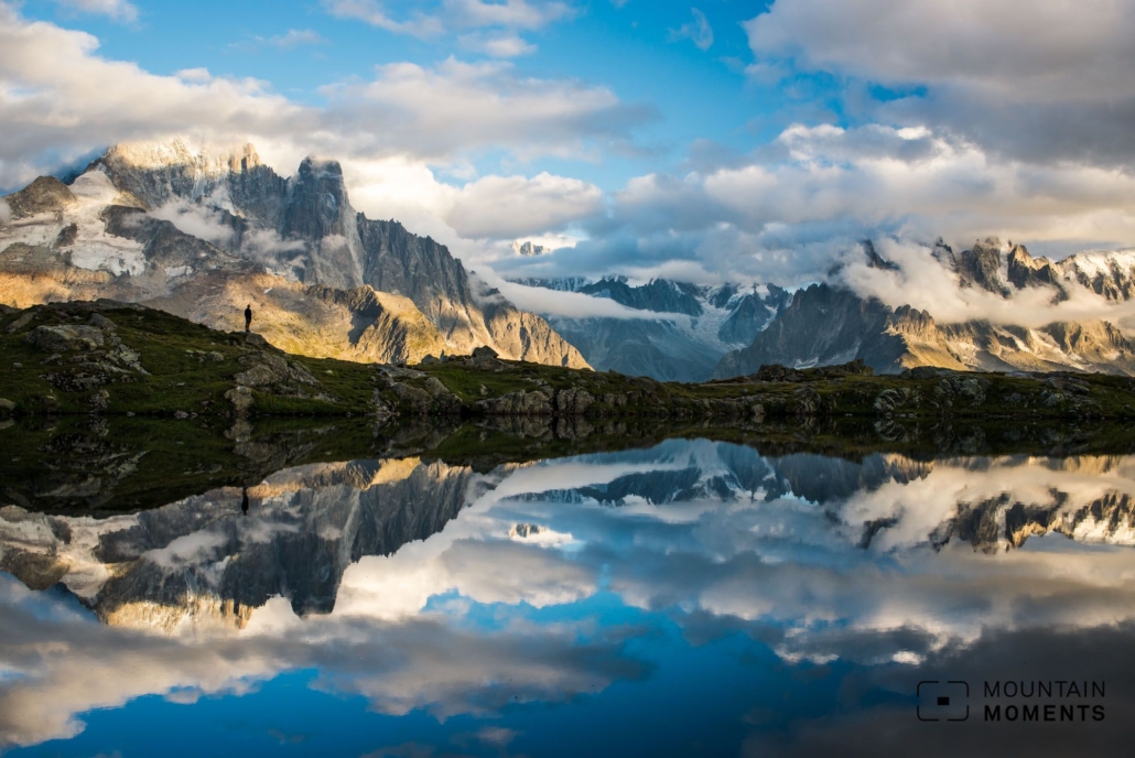
Lying there between Lac Blanc – the White Lake – and the smaller Lacs de Chéserys is undisputedly the most beautiful view of the entire Mont Blanc massif.
A wonderful half-day hike on this natural viewing balcony stretches from Col des Montets to Flégère. Along the way are several beautiful natural mountain lakes, from which an unobstructed view of the impressively mighty Mont Blanc massif opens up.
The steep mountain peaks from the Aiguille d’Argentière over the glacier basins of Glacier d’Argentière and Mer de Glace to the glaciated Mont Blanc peak can be admired here.

Directions! This is how yourhike to Lac Blanc looks like on a map
Starting point is the parking lot or the bus stop Col des Montets (1461m). Starting directly at the information building, follow the trail to “Grand Balcon Sud” and later towards Lacs des Chéserys/Lac Blanc. After some steeper hairpin bends, the path becomes flatter until Lac des Chéserys (2230m).
Immediately after, the trail climbs steeply again to Refuge Lac Blanc (2356m). From Refuge Lac Blanc downhill towards Flégère (1860m) and with the gondola into the valley. The starting point Col des Montets offers the easiest and most beautiful trail with a gentle slope.

Photo tips that will make your Instagram pop – the Mont Blanc massif and the White Lake
The views of the entire hike of the Mont Blanc massif are phenomenal. The White Lake (Lac Blanc) is particularly crowded. Quieter photo spots can be found at the slightly lower Lacs des Chéserys.


Mountain Moments Photo Workshops provide Photo Tours for everybody, Alpine Experience for beginners and intermediate-level photographers with 3 to 6-hour routes, as well as Summit Experience for more advanced photographers and hikers. We have private workshops and group classes.

More information about your next hiking adventure on the French Alps
How to get there by public transport: From Chamonix with bus no. 2 direction Le Tour, change in Argentière to bus no. 21 to Col des Montets. Alternatively, take the train to Montroc and get off at Trélechamps.
How to get there by car: Parking directly at the bottom station of the Flégère cable car. From here continue by train to Montroc and start at Trélechamps.
Start/finish: Col des Montets/Flégère or Argentière
Distance: 9km
Duration: 4h
Ascent/descent: 930m/480m
Highest point/lowest point: 2370m/1420m
Hike difficulty level: medium
Special features:
Meals: Refuge du Lac Blanc, Hotel La Flégère, Argentière, Chamonix.
Other tips: If you don’t want to take the gondola, you can walk down to the valley: 5h, 13km, 1200hm downhill. Return by train from La Joux/Argentière station or bus.
Contact: www.chamonix.com
The most beautiful photo spots and hikes in the Alps – experience this tour and 29 other exceptional hikes now.
 Fancy more hikes in the mountains – and beautiful photos? Get out into nature! Experience the best hikes and locations with our new book: Alps – Photo and Hiking Guide. The 90 best Photo Locations and 30 most panoramic Hikes.
Here we have compiled the most beautiful locations and photo opportunities. 30 hikes with 90 photo spots are selected and described in such a way that you can easily experience these wonderful landscapes for yourself – including GPS tracks and hiking map and all other information. ie schönsten Orte und Fotogelegenheiten in den Bergen zusammengefasst. 30 Wanderungen mit 95 Fotospots sind so ausgewählt und beschrieben, dass auch du diese wunderbaren Landschaften selbst erleben kannst – inkl. GPS Tracks und Wanderkarte und allen weiteren Infos.
You can take a closer look at the ebook here – why not give it as a gift to someone you want to visit and photograph these places with!
Of course, you will find all the information about this hike in the ebook. After registering, you will also receive the GPS track, so you are on the safe side and won’t get lost and will find all photo locations easily.

Hi, i am Marius, i love exploring the mountains and nature. Friends say, i know the mountains better than most locals, but actually i get lost all the time while photographing ;). Read more about the Mountain Moments Team.


