From Innsbruck City to the Sky – Catch our favourite Picture-Perfect Karwendel View at Nordkette and Goethe-Path
A 20-kilometer walk becomes pretty easy when sights around you disguise the respectable amount of distance covered. Who has the time to think about the physical effort, when Inn Valley and the city of Innsbruck stretch in front of you? This hiking route (called Goethe’s Hike) lies somewhere between “easy” and “difficult”, so many less experienced hikers love this combination of difficulty, length, and photo opportunities. Find all the information below, and join us for your next adventure.
It is Austria’s only city in the middle of an alpine mountain world: Innsbruck. The surrounding mountains can all be hiked, and in some cases, gondola lifts facilitate the ascent and descent directly from the city center.
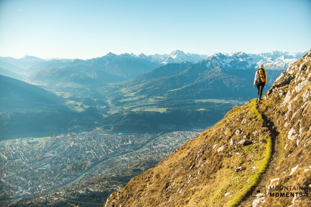
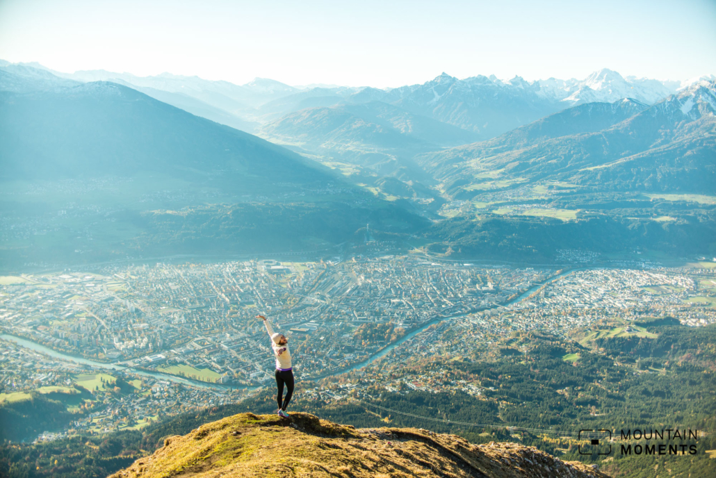
The view above Innsbruck at Goethe Path is nothing but fascinating.
The Nordkette is probably the only high alpine point in the world that can be reached directly from a medieval old town or university in the city center without any effort. From the Kongress station, the Hungerburg railway (Hungerburgbahn) and later the Nordkette cable car (Nordkettenbahn) lift you up from 600 to 2200 meters.
After 30 minutes you stand without any effort in the breathtaking high alpine terrain of the Karwendel mountains.
Directions for your Innsbruck climb: Goethe Path at Nordkette

The Nordkette cable car (Nordkettenbahn takes you comfortably from the Congress station to over 2200m in less than 30 minutes. From the Hafelekar station, walk a few minutes to the Hafelekarspitze (2334m).
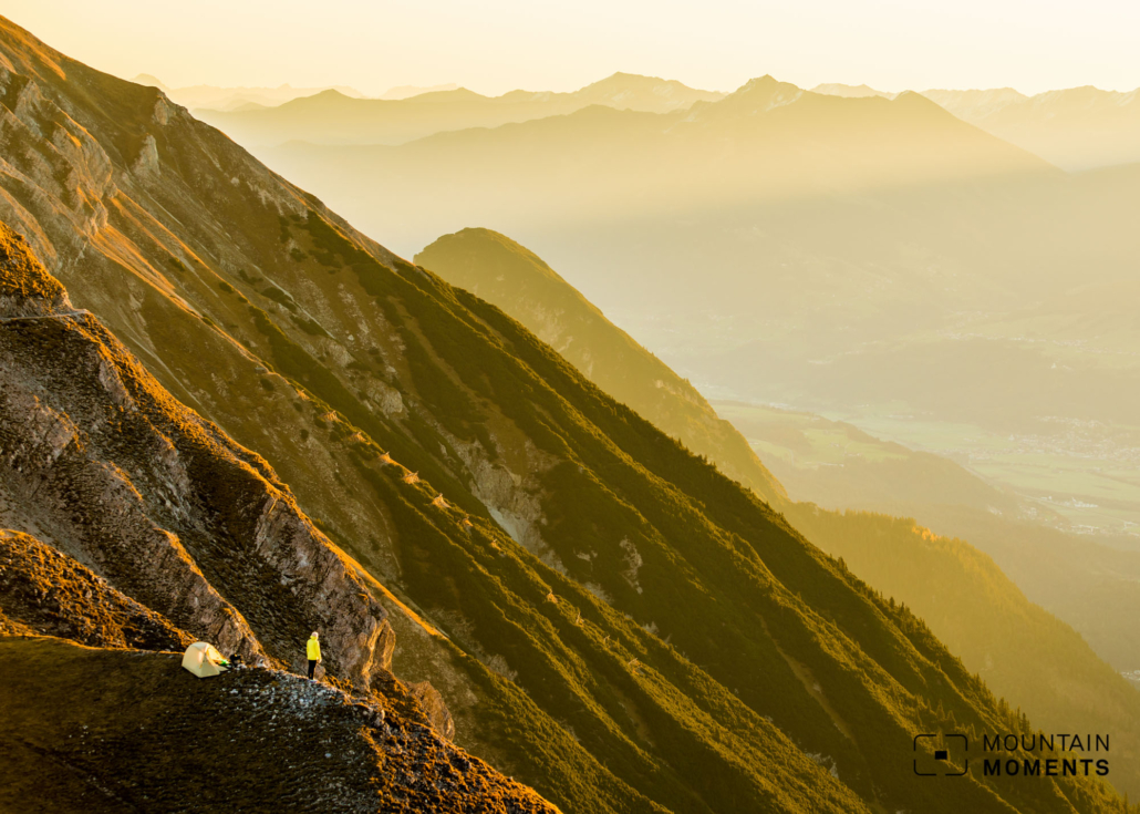
At the summit platform again briefly downhill, immediately turn right and follow the Goethe path towards Pfeishütte (1922m). The path is well maintained throughout, but still requires some head for heights. Then use the same way back. Note the opening hours of the mountain railroad.

Photo tips that will make your Instagram pop – Karwendel mountains and the Hungerburg Station viewing platform
The trail runs sometimes on the north side, sometimes on the south side of the ridge and opens up many views into the impressive Karwendel mountains and steeply down into the Inn valley. Both wide-angle panoramic shots with the city in the center and tele zoom photographs into the diverse mountain world are very rewarding.
The view just a few meters above the city directly at the Hungerburg Station viewing platform is also recommended.

Mountain Moments Photo Workshops provide Photo Tours for everybody, Alpine Experience for beginners and intermediate-level photographers with 3 to 6-hour routes, as well as Summit Experience for more advanced photographers and hikers. We have private workshops and group classes.

More information about your Innsbruck-Nordekette hiking adventure
How to get there by public transport: By bus/train to Innsbruck main station, continue by tram/bus (various) to Marie-Theresienstraße. Approx. 200m walk to Hunger burgbahn Station Congress.
How to ge there by car: Inntal autobahn A12 to Innsbruck West, direction Nordkettenbahn, parking lot Hunger burg Station (parking discount when using the cable car).
Start/destination: Mountain station Nordkettenbahn Hafelekar 47.311928,11.383676
Distance: 19.2km
Duration: 4h
Ascent/descent: 740m/740m
Highest point/lowest point: 2332m/1923m
Hike difficulty level: medium
Special features: Longer tour options without/reduced use of mountain railway.
Meals: Karstube, Seegruben Restaurant, Pfeishütte, Innsbruck.
Further tips: Alpine experienced can alternatively walk the Innsbruck via ferrata from Hafelekar.
Contact: www.nordkette.com
The most beautiful photo spots and hikes in the Alps – experience this hiking tour and 29 other exceptional regions now.
 Fancy more hikes in the mountains – and beautiful photos? Get out into nature! Experience the best hikes and locations with our new book: Alps – Photo and Hiking Guide. The 90 best Photo Locations and 30 most panoramic Hikes.
Here we have compiled the most beautiful locations and photo opportunities. 30 hikes with 90 photo spots are selected and described in such a way that you can easily experience these wonderful landscapes for yourself – including GPS tracks and hiking map and all other information. ie schönsten Orte und Fotogelegenheiten in den Bergen zusammengefasst. 30 Wanderungen mit 95 Fotospots sind so ausgewählt und beschrieben, dass auch du diese wunderbaren Landschaften selbst erleben kannst – inkl. GPS Tracks und Wanderkarte und allen weiteren Infos.
You can take a closer look at the ebook here– – why not give it as a gift to someone you want to visit and photograph these places with!
Of course, you will find all the information about this hike in the ebook. After registering, you will also receive the GPS track, so you are on the safe side and won’t get lost and will find all photo locations easily.

Hi, i am Marius, i love exploring the mountains and nature. Friends say, i know the mountains better than most locals, but actually i get lost all the time while photographing ;). Read more about the Mountain Moments Team.


