Amazingly Panoramic Via Ferrata on Beautiful Brenta Dolomites: Bocchette Hike- Route Map, Photo Tricks, and Safety Tips!
You want to experience of the most panoramic Via Ferrata of the Dolomites? Welcome to introduce you to Brenta Dolomites Bocchette Hike. All infos in the blog for your not so common Dolomites adventure – including hiking map!
Are you a sharpshooter when it comes to photography? If you don’t have your next hiking targets lined up, let us take you to the Province of Trentino in northeastern Italy, the location of the most beautiful via ferrata in the almost forgotten Brenta Dolomites.
Placed outside the central Dolomites – and not located directly on main roads or major cities – the Brenta is somewhat hidden, which makes this an insider tip, from us to you. Check out the map, tips, and tricks, grab your hiking equipment and join us!
The hard dolomite rock and some smaller glaciers create here an impressive landscape with often vertically reaching, massive rock faces. In these walls you can find incisions embedded here and there – they show up in the Brenta especially often as a ribbon-cutting through a rock face.

Route description – this is how your Via Ferrata trip to Brenta Dolomites (Bocchette Hike) looks like on a map
From the parking lot at the Vallesinella hut, the trail first leads slightly uphill through dense forest to the Casinei hut and the Brentei hut. For an overnight stay at the Alimonta hut (recommended), turn off just before the Brentei hut and climb the steep trail through alpine grass and some scree passages to the Alimonta hut.
The second day starts on a stony path up to the Sfulmeni Glacier (caution: danger of falling rocks, crevasses!). From Bocca degli Armi (2749m) the via ferrata starts over some shorter ladders. After a quick and striking straddle, the route leads over some easy, exposed rock ledges. Along the eastern flank, the via ferrata also crosses a larger gorge (photo spot).
After another longer band follows the famous and solitary rock needle Basso (Bocchetta di Campanile photo spot). From here, in addition to a few bands, there is a lot of walking terrain until just below the Bocca di Brenta, where the viafFerrata ends. From there, either choose the direct descent or take a short detour to the Tosa hut.
The final descent first leads over some rope-secured paths and scree passages. Later, descend on easy trails to the Brentei hut and back to the starting point.

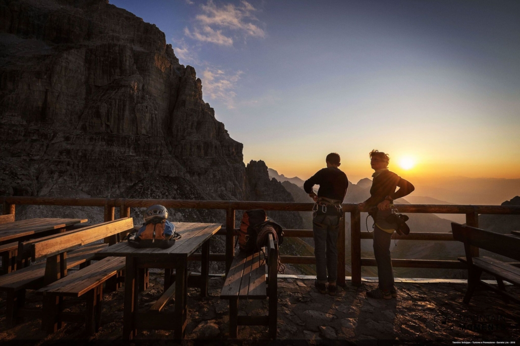
Photo tips that will make your Instagram pop – Campanile Basso, Sfulmeni Glacier and the sunset at the Alimonta
Along the often vertically sloping via ferrata we find numerous photo motifs. The best way to capture the breathtaking view is usually with a wide-angle lens. Don’t forget to secure yourself and your equipment.
The lonely rock needle Campanile Basso, the gorge at the via ferrata and the Sfulmeni Glacier are particularly exciting motifs. The cirque glacier is mostly in the shade and requires photographic sensitivity.
Do not forget: Self-protection of man and material.

Mountain Moments Photo Workshops provide Photo Tours for everybody, Alpine Experience for beginners and intermediate-level photographers with 3 to 6-hour routes, as well as Summit Experience for more advanced photographers and hikers. We have private workshops and group classes.
More information about your adventure on Brenta Dolomites
How to get there by car: Via A22 Brenner freeway to exit San Michele a. A. – Mezzocorona and continue to Madonna di Campiglio off in the center of the village, take a narrow road to the Vallesinella hut. Access is restricted depending on the season: Partial ban on cars!
How to get there by public transport: By train to Trento and by bus to Madonna di Campiglio. From there take the shuttle bus to the Vallesinella hut.
Duration: 12.5h
Distance: 18.6km
Ascent/descent: 2190hm/2190hm
Highest/lowest point: 2839m/1522m
Refreshments: Vallesinella hut, Casinei hut, Brentei hut, Alimonta hut, Tosa hut
Start/Finish: Vallesinella hut (coordinates: geogr. 46.206080, 10.852160)
Safety tips: Short glacier crossing! Crampons/rubber recommended (old snow remains). Via ferrata equipment, surefootedness and head for heights necessary.
The most beautiful photo spots and hikes in the Dolomites – experience this hiking tour and 29 other exceptional trips in the Dolomites now.
 Fancy more hikes in the mountains – and beautiful photos? Get out into nature! Experience the best hikes and locations with our new book: Alps – Photo and Hiking Guide. The 90 best Photo Locations and 30 most panoramic Hikes.
Here we have compiled the most beautiful locations and photo opportunities. 30 hikes with 90 photo spots are selected and described in such a way that you can easily experience these wonderful landscapes for yourself – including GPS tracks and hiking map and all other information.
You can take a closer look at the ebook here– – why not give it as a gift to someone you want to visit and photograph these places with!
Of course, you will find all the information about this hike in the ebook. After registering, you will also receive the GPS track, so you are on the safe side and won’t get lost and will find all photo locations easily.

Hi, i am Marius, i love exploring the mountains and nature. Friends say, i know the mountains better than most locals, but actually i get lost all the time while photographing ;). Read more about the Mountain Moments Team.


