Sweet and Challenging Marmolada Hike – Reach the Sky on Dolomites’s Highest Mountain
Marmolada sounds sweet and looks amazing in photographs, but it is not for faint-hearted as far as hiking is concerned. For those more experienced who love challenging hikes and can’t wait to connect with nature on Dolomite’s highest mountain, we have a 9.4km long treat for you. Find out about the trip difficulty, how to reach this destination and what to focus on with your camera.
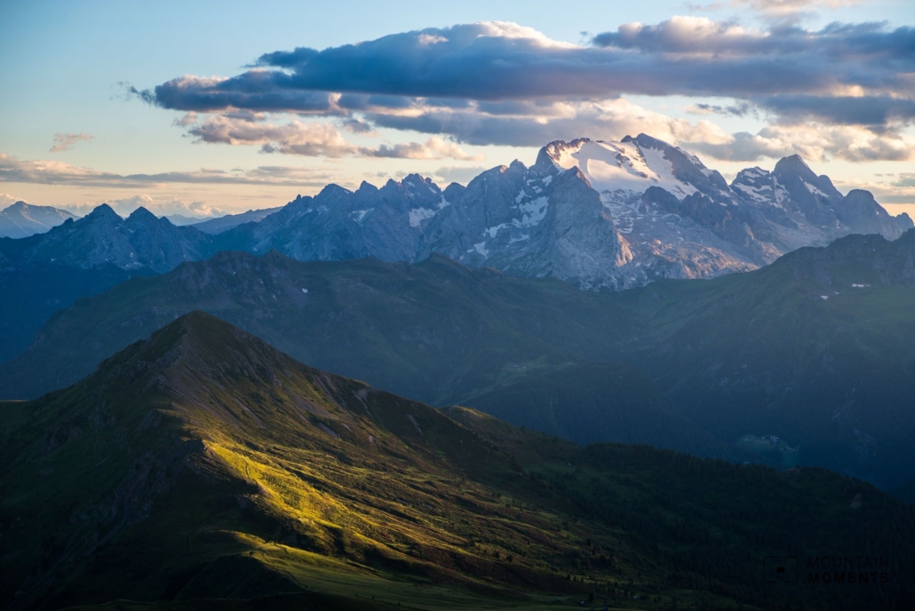
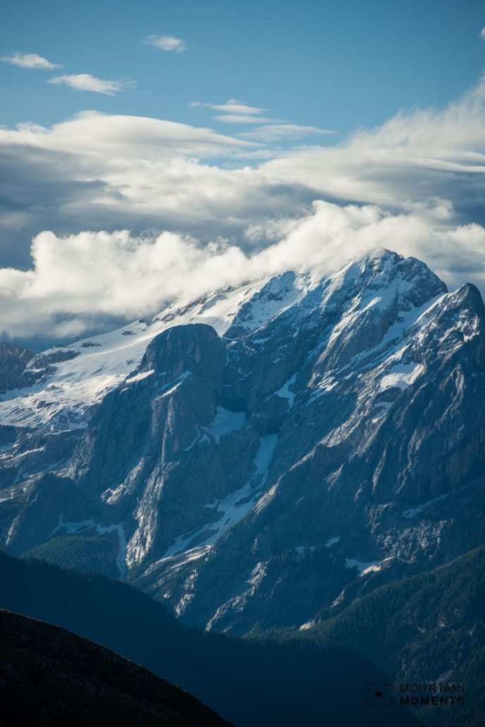
With up to 800 meters in altitude, the Marmolada south face is one of the most imposing walls in the Eastern Alps. The highest peak of the Dolomites with the largest glacier in the region can be reached via a challenging via ferrata.
The west ridge via ferrata was built in as early as 1903, making it one of the oldest via ferrata routes in the Southern Alps. Nevertheless, it has lost none of its uniqueness. The medium-difficulty via ferrata (B) leads over the exposed ridge on a knife’s edge, always with the fearsome view of the imposing south face down into the Ombretta valley.
The descent takes place over the Marmolada glacier (crevasses!), which is why the high altitude tour is not to be underestimated and accordingly high altitude touring experience is a basic requirement. Marmolada had already been in the First World War a great tactical importance for the war of position between Austria and Italy.
The sad milestone was the catastrophic avalanche on December 13, 1916, which cost the lives of about 300 Austrians. This avalanche accident is considered one of the worst avalanche accidents in history. Today, the Marmolada is a center of attraction for numerous tourists, skiers, hikers as well as via ferrata fans both in summer and winter.
The glacier has melted dramatically in recent years, so the trail in this form will probably last only a few years or decades. Climbing this classic and photos of the dramatic glacier is a race against time.
Directions – this is how your Marmolada adventure looks like on a map
From the parking lot at the Fedaia reservoir, follow the stony trail uphill along the Fedaia-Pian dei Fiacconi basket lift to the Sforcela de Coi di Bousc. From there, climb straight up the scree-covered moraine slopes to the lower edge of the Vernel glacier.
Here it is already worthwhile to put on the via ferrata equipment and, depending on the conditions, the crampons. Walk along the glacier mostly in the middle and in the upper area cross to the right to the entrance of the via ferrata.
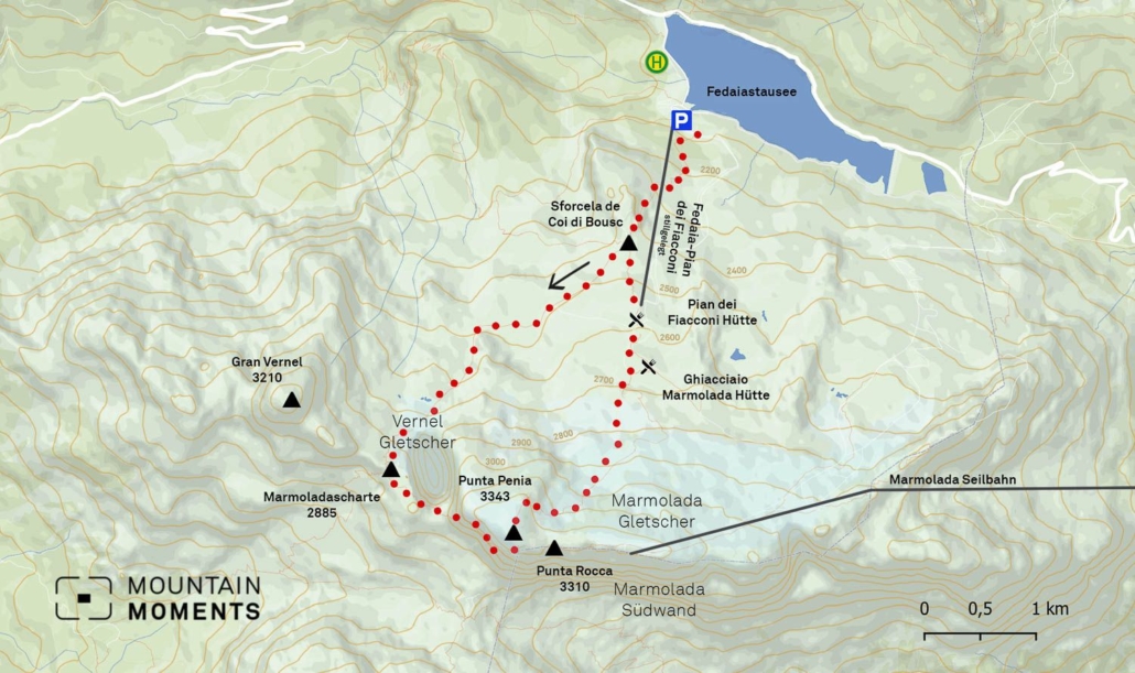
After a short entry step and an intersection, the Marmolada-Scharte is reached. Then climb along the via ferrata over the rocky ridge to the glacier at the Notbiwak (Capanna Punta Penia). Past the Notbiwak and to the Ponta Penia summit (3343m).
After a long lunch break, return towards Capanna Punta Penia and turn right a few meters before it. Depending on the conditions, form a rope team here and descend the glacier ridge. After about 100 meters of altitude, the rope tracks lead to the right over a short via ferrata passage to the Marmolada glacier.
The following glacier passage is characterized by various larger transverse crevasses. If there is bare ice in the steep area, possibly use ice screws as an intermediate belay. Then cross the glacier and follow the moraine trail to the Pian dei Fiacconi hut. From there, descend to the reservoir via the hiking trail already used in the ascent.
Marmolada magic – advice that will make your Instagram pop
The summit tour on the Marmolada has an incredible amount to offer for photographers, so temporal skill is necessary in order not to get into trouble on the descent.
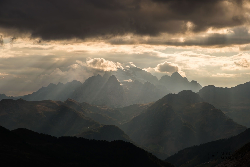
At the summit, the obligatory group photo is a must! To the north, the view extends over all the well-known Dolomite mountains to the Stubai and Zillertal Alps. To the south, the steep south face in connection with the Sasso Vernale is particularly striking.
On the descent, depending on the firn conditions, the crevasses are a magnificent motif. We recommend especially the close-up shots of the impressive crevasse zones in the descent from the bird’s eye view. But be careful: when taking close-up photos, please do not step too close to the edge of the crevasse, as the snow bridges can collapse!
Mountain Moments Photo Workshops provide Photo Tours for everybody, Alpine Experience for beginners and intermediate-level photographers with 3 to 6-hour routes, as well as Summit Experience for more advanced photographers and hikers. We have private workshops and group classes.
Information about your Marmolada hiking trip
How to get there by car: A22 Brennero freeway to the Chiusa exit, continue on the main road towards Ortisei. Continue via Selva Gardena and Canazei to the Fedaia reservoir. At the reservoir turn right until you reach the parking lot.
How to get there by public transport: By train via Innsbruck to Bolzano. With regional buses to Canazei. Change to a local bus or take a cab to the Fedaia reservoir.
Hike difficulty level: difficult
Duration/distance: 7.5h,/9.4km
Ascent/descent: 1300m/1300m
Highest/lowest point: 3343m/2094m
Refreshments: Pian dei Fiacconi hut, Ghiacciaio Marmolada hut, Capanna Cima Undici hut
Start/finish: Fedaia reservoir parking lot (Capanna Cima Undici) (coordinates: geogr. 46.457610, 11.864459)
Tips: Glacier descent unpleasant especially in blank ice or soft conditions in the afternoon, so early start recommended or descent via via ferrata. Overnight stay at Pian dei Fiacconi hut allows early departure.
Special dangers: Attention crevasses! Partial danger of falling! Insured via ferrata, scree fields, surefooted and head for heights required, crevasse-rich glacier crossings, steep ice passages (35°), avalanche danger especially with larger fresh snowfalls (old snow problem).
The most beautiful photo spots and hikes in the Dolomites – experience this hiking tour and 29 other exceptional trips in the Dolomites now.
 Fancy more hikes in the mountains – and beautiful photos? Get out into nature! Experience the best hikes and locations with our new book: Alps – Photo and Hiking Guide. The 90 best Photo Locations and 30 most panoramic Hikes.
Here we have compiled the most beautiful locations and photo opportunities. 30 hikes with 90 photo spots are selected and described in such a way that you can easily experience these wonderful landscapes for yourself – including GPS tracks and hiking map and all other information.
You can take a closer look at the ebook here– – why not give it as a gift to someone you want to visit and photograph these places with!
Of course, you will find all the information about this hike in the ebook. After registering, you will also receive the GPS track, so you are on the safe side and won’t get lost and will find all photo locations easily.

Hi, i am Marius, i love exploring the mountains and nature. Friends say, i know the mountains better than most locals, but actually i get lost all the time while photographing ;). Read more about the Mountain Moments Team.


