
Alpine Run on a 9-Kilometer Innsbruck’s Eichhoftrail – Map, Tips, and Video!
Innsbrucks finest trail run? Eichhoftrail iit may be. Enjoy gentle hills, small villages, forest and meadow paths, and tranquility. All infos and map.
Full nature submersion-feel with a reassuring notion that the city of Innsbruck, even though sometimes out of sight, is right there wherever you need it. Does this sound like an outdoor adventure fit for you? If so, join Mountain Moments on activity/photography adventure and enjoy gentle hills, small villages, forest and meadow paths, and tranquility.
The plateaus south of Innsbruck around Igls-Tulfes and Natters-Axams are what the locals like to call their “Mittelgebirge”. Compared to the high alpine, it is rather flat-hilly here. The areas rise only slightly above the city center, with an elevation of around 300 meters. Only a few kilometers from the city center and surrounded by high alpine peaks: the flair of a rural low mountain range is characteristic for this trail.
The Eichhoftrail leads from the city center into this low mountain range. Despite the tendency to be flat, there are still 250 meters of altitude to be climbed – you can’t do any less than that here. If you like, you can do a lot more running on the plateau and cover more distance.
Those who take the trail as a walk can enjoy a leisurely stop at Natterer See or Natterer Boden for Tyrolean specialties.
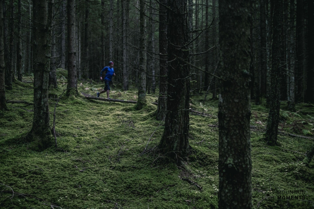
The trail is well signposted and leads along narrow hiking trails and less frequented forest and hiking paths through relaxed forest and meadow terrain
Description! This is how you Innscbruck running trail looks like on a map
The Eichhoftrail starts somewhat hidden at the information board to the Andreas-Hofer-Weg south of the Vaz harbor area after the Inntal highway underpass after a few meters of altitude (follow the GPS track).
On the right hand side the Andreas-Hofer-Weg uphill, immediately keep to the right and through a small settlement (Mentlberg) towards Mentlberg Castle. Do not continue to the castle, but keep left uphill and take the Natterer-See-Weg. At the crossroads, continue on the Natterer-See-Weg (path) and follow it uphill until shortly before the Natterer See(lake). Here turn left and follow the forest road on the left only slightly uphill to the Eichhof inn. Pass the inn and turn left directly into the Eichhofweg (path). After a short downhill stretch, turn right uphill and follow the signposted path along the edge of the slope in an easterly direction.
After a forest road section and a view of Innsbruck, turn left into the Herzogsteig. This leads downhill and about 20 hairpin bends later you are again on a fort road. Follow this to the right, always slightly downhill, and then turn slightly left onto the Andreas-Hofer-Weg and back to the starting point
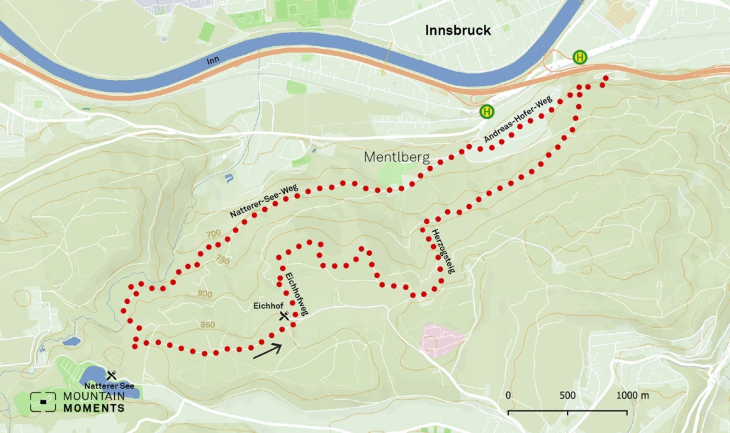
Photo tips that will make your Instagram pop – the meadow east of Gasthof Eichhof
The trail leads mostly along the north-facing forest and therefore invites you to take atmospheric forest pictures when the sun is low or when there is fog. The meadow east of Gasthof Eichhof is quite photogenic and is best photographed from the easternmost point, about 100m before you turn onto the Herzogsteig.

Mountain Moments Photo Workshops provide Photo Tours for everybody, Alpine Experience for beginners and intermediate-level photographers with 3 to 6-hour routes, as well as Summit Experience for more advanced photographers and hikers. We have private workshops and group classes.
More information about your nature adventure in the Austrian Alps
How to get there: –
How to get there by public transport: –
Hike difficulty level: easy-medium
Duration/distance: 1.5h/ 9km
Ascent/descent: 275m/275m
Highest/lowest point: 855m/605m
Refreshment stop: Lake Natterer See, Eichhof Inn
Start/finish: Starting point Andreas-Hofer-Weg (coordinates: geogr. 47.253085,11.378762)
Best time: March-October
Tips: As a walk, a stop at Gasthaus Eichhof or Natterer See is recommended.
The best Summer Adventures in and around Innsbruck – Hiking, Mountainbiking, Trekking, Climbing and more

Fancy more Summer Adventures in Tyrol and around Innsbruck? We got you covered! The best outdoor sports activities for Summer Enthusiasts as eBook: Innsbruck Summer Outdoor Guide.
Here we have compiled the most beautiful locations and photo opportunities. 30 activities with numerous photo spots are selected and described in such a way that you can easily experience these wonderful adventures around Innsbruck for yourself – including track infos, and maps and all other information that you need.
You can take a closer look at the Innsbruck travel guide ebook here – why not share it with your adventure partner?

Hi, i am Marius, i love exploring the mountains and nature. Friends say, i know the mountains better than most locals, but actually i get lost all the time while photographing ;). Read more about the Mountain Moments Team.


