
Tegernseer Hut Hike! Visit Picturesque Hut on a Side of the Mountain
Edgy and exciting Tegernseer Hütte embedded between two rugged Alpine peaks provides exactly the right feelings hikers are looking for, and just the right views nature photographers dream about.
Mountain Moments brings you another awesome hiking choice in the Alps, along with a route map, expert hiking advice, and professional photo tips and tricks as a part of comprehensive but easy-to-understand photography workshops.
What’s so special about this hiking route? This is what awaits you on the location
Here, in the inconspicuous Mangfall mountains between the double peak Roßstein and Buchstein, is the spectacularly situated Alpenvereins hut. As expected, this spot inspires many hikers, which makes this hiking destination a popular choice. If you want, you can complete the hike with a short but challenging climb on the Buchstein.
Directions! This is how your Alpine adventure looks like on a map
The starting point is the Tegernseer Hütte bus stop or car park on the B307 near Kreuth/Bayerwald. Directly at the car park, the path leads us steeply in serpentines through the forest (always keep in the direction of the Tegernseer hut) up over the Sonnbergalmen.
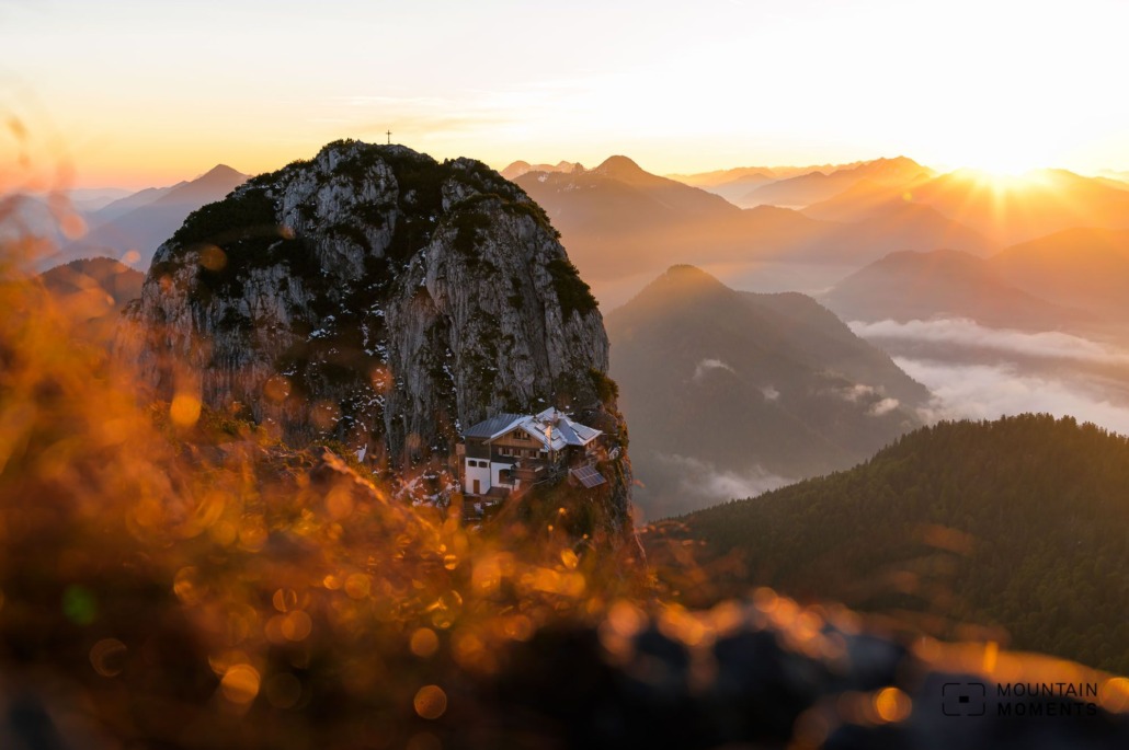
After the alpine meadow, the direct ascent with a few challenging sections goes straight uphill over the Roßstein (1698m) to the vantage point – and a few meters further to the Tegernseer hut.
For the descent, we hike from the Roßstein Alm via the hiking trail to the Röhrlmoos Alm. It goes along the Schiffbach to Glashütte. Briefly at the main road left to the east, turn into a forest path. After 500 meters we reach the starting point.
This 9.4-kilometer route is moderately difficult and can be finished in under four hours.

Alternatives
The descent described here is the much easier way. Less experienced hikers also choose this as a climb.
A short climb on the Buchstein (1701m) from the Tegernseer hut: directly behind the hut on the right past the steep chimney to the summit (climbing difficulty level II). Other climbing routes are also possible.
Photo tips that will make your Instagram pop! The right camera settings for Tegernseer Hütte
The special location of the Tegernseer Hütte is the undisputed Instagram star of this hike. We have the best photo spot for this view at the Roßstein summit structure. Here the hut presents itself in all its glory. A photo from this perspective is particularly recommended at sunrise in midsummer or in autumn.
When taking this shot against the sun, make sure that you have the right exposure: since the hut is in the shadow of the Buchstein for a long time, you have to expose it manually – or take the detour of multiple exposures (usually with a tripod).
Mountain Moments Photo Workshops provide Photo Tours for everybody, Alpine Experience for beginners and intermediate-level photographers with 3 to 6-hour routes, as well as Summit Experience for more advanced photographers and hikers. We have private workshops and group classes.
A graded neutral density filter can also be useful here from time to time. But maybe our smartphone will already take the picture perfectly! As always, many paths lead to the same goal.
For a successful photo, it is best to spend the night in the hut. Reservation is recommended.


More information about your hiking trip – from arrival to the finish line
Arrival: B307 Tegernsee Kreuth direction Achensee. Bayerwald/Tegernseer Hütte car park south of Kreuth (signposted, subject to a fee).
Public transport: By train to Tegernsee, change to bus 9550 in the direction of Pertisau and get off at the Tegernseer Hütte stop.
Difficulty: medium
Duration: 4 hours, 9.4 km
Ascent/descent: 850hm/850hm
Highest/lowest point: 1698m/859m
Refreshment stops: Sonnberg Alm, Tegernseer Hütte, Roßstein Alm
Start/finish: car park/bus stop Buchstein/Kreuth/Tegernseer Hütte Landesstraße B307 (coordinates: geogr. 47.615891, 11.676793)
Particular dangers: Difficult climb to the Roßstein. The described bypass via the Roßstein Alm is easier.
Tips: The sleeping places in the huts are particularly popular at the weekend, reservations are necessary.
The most beautiful photo spots and hikes in the German Alps – experience this hiking tour and 29 other exceptional regions now.

Fancy more hikes in the mountains – and beautiful photos? Get out into nature! Experience the best hikes and locations with our new book: German Alps – Photo and Hiking Guide. The 90 best Photo Locations and 30 most panoramic Hikes.
Here we have compiled the most beautiful locations and photo opportunities. 30 hikes with 90 photo spots are selected and described in such a way that you can easily experience these wonderful landscapes in Bavaria for yourself – including GPS tracks and hiking map and all other information.
You can take a closer look at the ebook here – why not give it as a gift to someone you want to visit and share?

Hi, i am Marius, i love exploring the mountains and nature. Friends say, i know the mountains better than most locals, but actually i get lost all the time while photographing ;). Read more about the Mountain Moments Team.


