Risk and Reward on Augstmatthorn – Hike on the Steep Meadow Ridge in the Swiss Alps!
Augstmatthorn, a mountain range in the Emmental Alps is not easy to reach and cover, but that does not stop experienced hikers in their tracks. More than that, the sights this location provides motivate the less experienced backpackers and nature photographers to gain the needed experience, so they could one day be safe on the kind of hiking adventure mentioned here. Are you skilled enough? If so, check out the map and our photography tips and tricks, grab your hiking equipment, and join us.
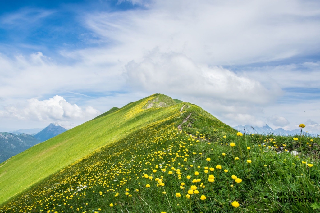
This rich and magnificent mountain meadows nestle on the steep and grassy Augstmatthorn mountain slopes. As if painted, they lead into many sweeps towards the horizon. A 1500 meters of descent down to Lake Brienz and Interlaken reinforce the airy impression.
This impressive hike leads along an extraordinary steep meadow ridge: The Brienzergrat (also known as the Hardergrat). This tour avoids the main path that most mountain visitors take from Interlaken to the Harder Kulm.
Those who choose this route, therefore, will be rewarded with a solitary hike and, in addition, the site of the amusingly situated Graaggetor.


Route description – this is how your Augstmatthorn-oriented journey looks like on a map
The starting point is at Ringgenberg railroad station. Proceed shortly west across the main road and then uphill. Follow the hiking trail via Stocki to Inders Blatti until you cross the road. Continue directly steeply uphill to the Graaggetor.
From here you will take approximately 15 minutes to the ridge. At the ridge turn right and maintain the path along the ridge to the Augstmatthorn (2136m). From the Augstmatthorn stick along the ridge back west there are several ups and downs to the Harder Kulm panorama restaurant.
Finally, take the Harder Kulmbahn back to Interlaken (note operating times). Alternatively, walk another 750 meters downhill to Interlaken.

Photo tips that will make your Instagram pop – the view at the Augstmatthorn and Lake Interlaken at Brienzergrat (Brienzer Ridgeline)
The star of this challenging tour is the view at the Augstmatthorn. A nice photo spot is located in front of the Augstmatthorn at the Suggiture. The Graaggetor is also a worthwhile photographic souvenir, as is the view at Harder Kulm. In the nature reserve – from about Roteflue – the probability of encountering rock deer is very high.

Have your camera handy, and remember the trips and tricks Mountain Moments provided you with

Mountain Moments Photo Workshops provide Photo Tours for everybody, Alpine Experience for beginners and intermediate-level photographers with 3 to 6-hour routes, as well as Summit Experience for more advanced photographers and hikers. We have private workshops and group classes.

More information about this challenging hiking adventure in Interlaken
How to get there by public transport: take the train to Meiringen or Interlaken, change trains here and travel to Ringgenberg station.
How to get there by car: this will be via Bern or Brünigpass to Interlaken. Then another car or better a train to Ringgenberg.
Start/finish: Ringgenberg/Harder Kulm-Interlaken
Distance: 16km
Duration: 7h
Ascent/descent: 1690m/980m
Highest point/lowest point: 2136m/565m
Hike difficult level: difficult
Caution: Tour not recommended in wet conditions because of danger of slipping and falling. Not recommended also for those with phobia for heights and surefootedness is a must. Nature reserve.
Refreshments: No food on the way, only at the end of the tour at Harder Kulm.
Further tips: Use public transport at Augstmatthorn nature reserve of a stone deer colony.
Contact: www.interlaken.ch
The most beautiful photo spots and hikes in the Alps – experience this hiking tour and 29 other exceptional regions now.
 Fancy more hikes in the mountains – and beautiful photos? Get out into nature! Experience the best hikes and locations with our new book: Alps – Photo and Hiking Guide. The 90 best Photo Locations and 30 most panoramic Hikes.
Here we have compiled the most beautiful locations and photo opportunities. 30 hikes with 90 photo spots are selected and described in such a way that you can easily experience these wonderful landscapes for yourself – including GPS tracks and hiking map and all other information.
You can take a closer look at the ebook here– – why not give it as a gift to someone you want to visit and photograph these places with!
Of course, you will find all the information about this hike in the ebook. After registering, you will also receive the GPS track, so you are on the safe side and won’t get lost and will find all photo locations easily.

Hi, i am Marius, i love exploring the mountains and nature. Friends say, i know the mountains better than most locals, but actually i get lost all the time while photographing ;). Read more about the Mountain Moments Team.


