Hiking from Herzogstand to Heimgarten – Take the Best Photos of the Bavarian Alps
Herzogstand, a mountain in the Bavarian foothills, offers everything passionate hiker anticipates and dreams of – beautiful panorama, grand and impressive walls, breathtaking sunsets, and the wondrous night sky. Are you up for a challenge? All information you need to know can be found here, from distance and duration of the hike to amazing photos and the map of this popular route.
From Herzogstand to Heimgarten exists a magnificent ridge traverse. With heavenly views of the Bavarian Alps and their foothills, this hike may well be called the most beautiful hike in Munich’s local mountains!

A true pleasure tour for mountain lovers with an easy variant for casual hikers. Even the Bavarian dukes Wilhelm IV and Ludwig X knew to appreciate the view here. Towards the south, you look at the rugged Karwendel Mountains walls, while towards the north are the southern Bavarian alpine foothills.
In between these two poles, Lake Walchen (Walchensee) and Lake Kochel (Kochelsee) sparkle and invite you for a refreshing swim on warm summer days. Those who see pure photography as the reason for their excursion can spend the night at the Herzogstandhaus (Herzogstand hut) or park at the Kesselberg parking lot and use the forest road on foot downhill (900 meters in altitude).

This is how your amazing Herzogstand-Heimgarten journey looks like on a map
The Herzogstand-Heimgarten traverse starts about 100m to the right of the cable car station (819m). The narrow path always leads up the steep southern slope directly to the Herzogstandhaus (1573m). Surefootedness and a slight head for heights on the steep grassy slopes and rope-secured places is recommended.

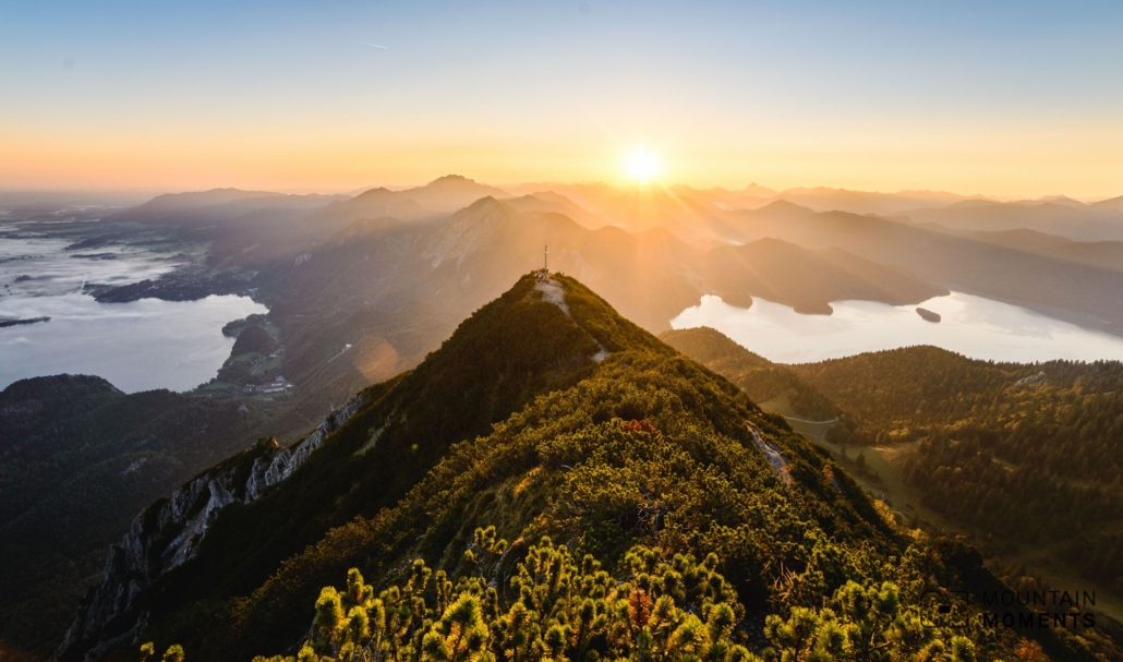
From the Herzogstandhaus it is about 30 minutes on an easy hiking trail to the summit structure with the pavilion (1732m, slightly above the cross). Here is probably the most beautiful photo spot with a 360° view. The transition to Heimgarten is a steep ridge hike, which is, however, very well secured (alpine experience necessary).

After about 1.5 h you reach the equally scenic Heimgartenhütte (Heimgarten hut) just below the Heimgarten summit (1791m). The descent in the direction of Walchen leads without particular difficulty along a path across the Öhlstädter Alm (hut) through mountain pines, forests, and meadows. At the saddle (1413m) go straight ahead and after a short count ascent the well-built hiking trail which leads over many serpentines until shortly before Walchen.
Here, finally, in the last kilometer keep to the left and over the Deiningbach (river) back to the starting point.
Easy variant: ascent with the Herzogstandbahn (gondola) and 30 minutes to the summit pavilion on an easy hiking trail. Take the same way back.

Mountain Moments Photo Workshops provide Photo Tours for everybody, Alpine Experience for beginners and intermediate-level photographers with 3 to 6-hour routes, as well as Summit Experience for more advanced photographers and hikers. We have private workshops and group classes.
Photo tips for Kochel and Walchen that will make your Instagram pop
The most famous photo spot is directly at the summit of the Herzogstand at the summit pavilion. From here, it’s best to take photos at sunrise with a wide-angle to the west and main focus at Kochel and Walchen.
The summit cross is located a few meters below the summit. The view from Heimgarten is no less impressive, with a magnificent panorama. As soon as the sun sets, it is advisable to also let your gaze wander towards the mountain peaks of the Karwendel (south) and to use a telephoto lens.

Information about your Herzogstand-Heimgarten route
How to get there by public transport: From Munich to Kochel am See, from Garmisch-Partenkirchen or Innsbruck by train to Mittenwald. From here in each case continue with RVO bus No. 9608 stop Herzogstand cable car, www.rvo-bus.de (about every hour).
How to get there by private car: From Munich A 95 in the direction of Garmisch-Partenkirchen, exit Kochel am See via Kesselbergstraße to Walchen (parking Herzogstandbahn 4.00 euros, as of 2020).
Start/finish: Herzogstandbahn (806m) (coordinates: geogr. 47.595968, 11.316954, UTM 32T 674175 5273996)
Hike difficulty level: difficult
Distance: 14.2km
Duration: 7h
Ascent/descent: 1186m
Highest/lowest point: Heimgarten (1791m)/Walchen (804m)
Catering: Heimgartenhütte, Herzogstandhaus (overnight stay possible)
Safety tips: Surefooted and some head for heights necessary. Inexperienced people should choose the alternative route with cable car transport or hike from/to Kesselbergpass.
Contact: www.tourismus.kochel.de
The most beautiful photo spots and hikes in the Alps – experience this hiking tour and 29 other exceptional regions now.
 Fancy more hikes in the mountains – and beautiful photos? Get out into nature! Experience the best hikes and locations with our new book: Alps – Photo and Hiking Guide. The 90 best Photo Locations and 30 most panoramic Hikes.
Here we have compiled the most beautiful locations and photo opportunities. 30 hikes with 90 photo spots are selected and described in such a way that you can easily experience these wonderful landscapes for yourself – including GPS tracks and hiking map and all other information.
You can take a closer look at the ebook here– – why not give it as a gift to someone you want to visit and photograph these places with!
Of course, you will find all the information about this hike in the ebook. After registering, you will also receive the GPS track, so you are on the safe side and won’t get lost and will find all photo locations easily.

Hi, i am Marius, i love exploring the mountains and nature. Friends say, i know the mountains better than most locals, but actually i get lost all the time while photographing ;). Read more about the Mountain Moments Team.


