Hiking Trip For All Ages – Explore the Geisler Alm, Geisler Peaks and the Adolf Munkel Trail
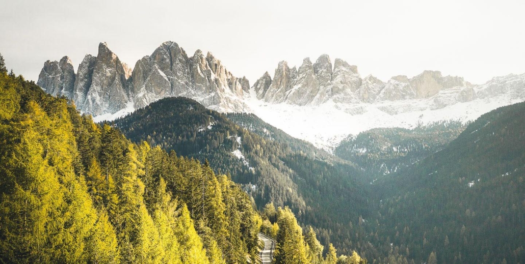
In the heart of the Dolomites, on the Adolf Munkel Trail of Villnöss Valley, your own heart might skip a beat. This is what happens when you hike on the gorgeous Geisler Mountain, even if it’s “only” 4 hours. This is how long it takes to cover the distance of 12,4 kilometers, and now you will find out how you too can enjoy these breathtaking peaks and valleys.
Rustic alpine pastures, imposing rock formations as well as an impressive plant world. This probably describes the ideal idea of many family tours. This is exactly what the magnificent round trip on the Adolf Munkel Trail in the bans of the Geisler Group in the Villnöss Valley offers.
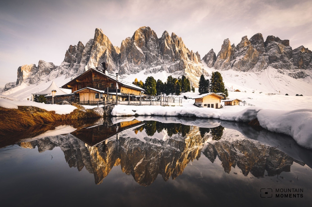
The circular hike runs along easy hiking trails and invites you to linger at four traditional alpine huts. Especially the views from the terraces of the Geisler hut and the Gampen hut to the up to 650 meters high north faces of the Geisler peaks are a very special experience for all ages. A highlight is the diverse flora of the green Gampen meadows near the Gampen hut.
With a length of over 12km, the undertaking is a full-day tour. However, it can be shortened via various forest paths. The mountain pastures offer themselves as an enjoyable lunch break. They are famous for their traditional dishes with regional cheese and fresh bread. It is also worthwhile to pull out your camera and take pictures of the huts with the Geisler peaks and the green meadow.
Route description Villnöss – Geisler Alm: this is how your amazing journey looks like on a map

Starting point is the parking lot of the Zanser hut. Here first in the direction of Zanser hut and shortly before it turn right in the direction of Dusler hut. First on a height and then slightly uphill to the Dusler hut. Continue south and in a curve to the Geisler hut.
Then the path leads in the direction of the Geislerspitzen until you reach the Adolf Munkel path. At the junction take the path to the left and follow the hiking trail parallel to the Geisler group. At the same time enjoy the unobstructed view of the north walls and stop regularly for a few photos.
Pass the Adolf Munkel memorial stone and alternate up and down a bit until you reach the far-reaching Gampen meadows with the Gampen hut. The last stage crosses the Gampen meadows and finally runs parallel to the Gasserill stream to the starting point.
Photo tips at Geisleralm that will make your Instagram pop
The most popular photo spots are in the immediate vicinity of the Geisler hut and the Gampen hut. At the Geisler hut, it is best to walk a few meters north to a small hill in order to photograph the lush meadow with the alpine hut and the Geisler peaks behind it. There is also a similar perspective at the Gampen hut.

In addition, the wide Gampen meadows are imposing. Other photo spots are at the small bouldering and climbing rocks along the Adolf Munkel path. We met some climbers there on the rocks, which were invigorating elements for us.
Directly behind them, often strongly pronounced moraine tracks connect. Together with old snow fields in the rock cirques and the Geislergruppe, there is a wide range of photo opportunities for different tastes.
Information about your route
How to get there by car: Brenner freeway until exit Chiusa. Via commercial zone Putzen drive in the direction of Villnösstal and finally to the end of the valley. Start at the parking lot of the Zanser Alm (approx. 6€ discount with guest card).
How to get by public transport: By train/bus to Klausen/Chiusa. Here change to the bus to Villnösstal and go to the stop Zanser-Hütte.
Hike difficulty level: easy – medium
Duration/distance: 4h, 12,4km
Ascent/descent: 600hm/600hm
Highest/lowest point: 2073m/1657m
Refreshment stop: Zanser Schwaige, Dusleralm, Geisleralm, Gschnagenhardtalm, Gampenalm
Start/finish: Bus stop/parking lot meeting point Zans (coordinates: geogr. 46.635852, 11.765457)
The most beautiful photo spots and hikes in the Dolomites – experience this hiking tour and 29 other exceptional trip in the Dolomites now.
 Fancy more hikes in the mountains – and beautiful photos? Get out into nature! Experience the best hikes and locations with our new book: Alps – Photo and Hiking Guide. The 90 best Photo Locations and 30 most panoramic Hikes.
Here we have compiled the most beautiful locations and photo opportunities. 30 hikes with 90 photo spots are selected and described in such a way that you can easily experience these wonderful landscapes for yourself – including GPS tracks and hiking map and all other information.
You can take a closer look at the ebook here– – why not give it as a gift to someone you want to visit and photograph these places with!
Of course, you will find all the information about this hike in the ebook. After registering, you will also receive the GPS track, so you are on the safe side and won’t get lost and will find all photo locations easily.
Fancy more hikes in the mountains – and beautiful photos? Get out into nature! Experience the best hikes and locations with our new book: Alps – Photo and Hiking Guide. The 90 best Photo Locations and 30 most panoramic Hikes.
Here we have compiled the most beautiful locations and photo opportunities. 30 hikes with 90 photo spots are selected and described in such a way that you can easily experience these wonderful landscapes for yourself – including GPS tracks and hiking map and all other information.
You can take a closer look at the ebook here– – why not give it as a gift to someone you want to visit and photograph these places with!
Of course, you will find all the information about this hike in the ebook. After registering, you will also receive the GPS track, so you are on the safe side and won’t get lost and will find all photo locations easily.

Hi, i am Marius, i love exploring the mountains and nature. Friends say, i know the mountains better than most locals, but actually i get lost all the time while photographing ;). Read more about the Mountain Moments Team.


