Royal Photos of King’s Lake – Hiking Treasure Map to Berchtesgaden National Park
Here at Mountain Moments, we have many treasure maps, with plenty of clues and re-discoverable rewards that are shared, instead of plundered. The picture-perfect example is the Berchtesgadener Land, one of the most beautiful landscapes in Germany, and King’s Lake (Königssee) and Upper Lake (Obersee), which come with the adjacent mountains and are reminiscent of Norwegian fjords. Bring your hiking equipment and your camera, and let’s sail (hike) toward this destination together.
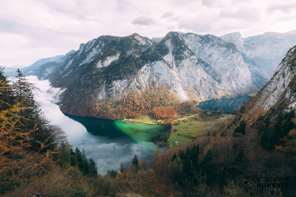
The two lakes are located in the middle of the Berchtesgaden National Park and offer numerous exciting photo motifs for alpine fans. The church of St. Bartholomä in front of the impressive Watzmann east face and the boathouse at the Upper Lake are the most famous among them.
The presented short and easy hike connects to a boat trip on the King’s lake. A few hundred meters further on, the wonderful Röthbach waterfall is still worth a visit. A direct hike around the King’s lake is not possible.

Photo tips that will make your Instagram pop – lakes and the church of St. Bartholomä
King’s lake is undisputedly a tourist hotspot. A photo with the church of St. Bartholomä and the Watzmann mountain east face rising massively behind it is particularly popular. The best option for this motif is to move to the right side of the boat on the outward journey.
Another possibility to capture the surroundings photographically is offered to us directly when we reach the Upper Lake. When looking across the lake to the Röthbachfall with and without fishing hut is almost always guarantee a successful photo.
Attention: The famous natural pools photo spot at Königssee are with June 30th 2021 officially forbidden to visit. It’s a natural reservat and the Rangers will control the paths leading to this spot – the fine will be up to 25.000 Euro. Please stay strictly on marked path! The viewpoint featured in this hike is perfectly in line with official rules. When you stick to the marked path you not only are safe from an unpleasant fine, you also help to protect the natural reservat. Thank you!


Mountain Moments Photo Workshops provide Photo Tours for everybody, Alpine Experience for beginners and intermediate-level photographers with 3 to 6-hour routes, as well as Summit Experience for more advanced photographers and hikers. We have private workshops and group classes.
Directions! This is how your trip to Berchtesgaden National Park looks like on a map
From Schönau am Königssee by boat to the landing stage Salet (605m). From here the hike starts along the lake and past the Saletalm. Follow the Funkelalm route to the alpine pasture of the same name for a few hundred meters slightly uphill to the viewpoint at Upper Lake.
Follow the path further to the Fischunkelalm (620m). Depending on your preference, you can follow the valley inwards to the wonderful Röthbachfall. Afterwards you go back on the same way.

More information about your adventure in the Bavarian Alps
How to get there by public transport: By train to Berchtesgaden, from here continue by bus to King’s lake. Very good public transport connection, www.rvo-bus.de.
How to get there by car: From Munich freeway A8 to Bad Reichenhall and via Bischofswiesen (B20) to Berchtesgaden and further to Schönau am Königssee. (High parking lot fee at King’s lake).
Start/finish: Schönau am Königssee landing stage Salet (598m) 47.525163,12.972965
Distance: 5.5km
Duration: 1:40h
Ascent/descent: 105m/105m
Highest point/lowest point: 662m/605m
Hike difficulty: Easy
Special features: Beautiful family day trip, other alpine tours from/to this tour for experienced mountain hikers.
Catering: Saletalm, Fischunkelalm, St. Bartholomä, Schönau am Königssee.
Further tips: High visitor frequency at weekend and vacation times. On the way back by boat, a detour to St. Bartholomä can also be worthwhile.
Contact: www.koenigssee.de
The most beautiful photo spots and hikes in the Alps – experience this hiking tour and 29 other exceptional regions now.
 Fancy more hikes in the mountains – and beautiful photos? Get out into nature! Experience the best hikes and locations with our new book: Alps – Photo and Hiking Guide. The 90 best Photo Locations and 30 most panoramic Hikes.
Here we have compiled the most beautiful locations and photo opportunities. 30 hikes with 90 photo spots are selected and described in such a way that you can easily experience these wonderful landscapes for yourself – including GPS tracks and hiking map and all other information. ie schönsten Orte und Fotogelegenheiten in den Bergen zusammengefasst. 30 Wanderungen mit 95 Fotospots sind so ausgewählt und beschrieben, dass auch du diese wunderbaren Landschaften selbst erleben kannst – inkl. GPS Tracks und Wanderkarte und allen weiteren Infos.
You can take a closer look at the ebook here– – why not give it as a gift to someone you want to visit and photograph these places with!
Of course, you will find all the information about this hike in the ebook. After registering, you will also receive the GPS track, so you are on the safe side and won’t get lost and will find all photo locations easily.

Hi, i am Marius, i love exploring the mountains and nature. Friends say, i know the mountains better than most locals, but actually i get lost all the time while photographing ;). Read more about the Mountain Moments Team.


