Hochstaufen Hiking Challenge! Map for a Difficult Trail in the Chiemgau Alps
The Hochstaufen mountain, which marks the eastern edge of the Chiemgau Alps, challenges experienced hikers and photographers with a 13.5-kilometer route north of the Bavarian Alpine town Bad Reichenhall.
Mountain Moments will share with you interesting stories about the location, a trail map, and expert hiking advice. For photography enthusiasts, we have prepared comprehensive but easy-to-understand photography workshops that will help you make the most out of your camera.
What’s so special about this hiking route? This is what awaits you on the location
According to legend, the two impressive rocks are hunters who looked too deep into their shot glass and did not show up for Holy Mass after a failed hunt.
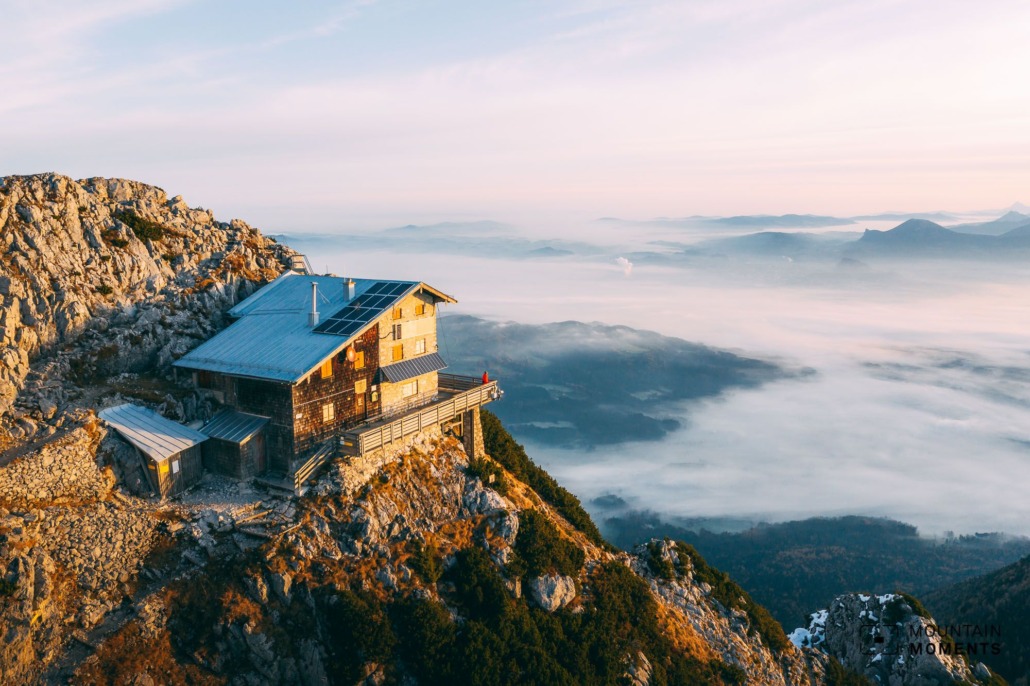
Today, on the other hand, we are careful not to drink too much schnapps at the Reichenhaller Haus, because the tour over the difficult climb demands a lot from us.
There is also an easier hiking trail that makes the ascent to the Hochstaufen easier, but we are still threatened with a different kind of petrification here, namely when we forget the time with the formidable view at sunrise and get frostbitten fingers from taking pictures! The striking, free-standing Hochstaufen is definitely worth the arduous ascent.

Directions! This is how your hiking route looks like on a map
The starting point of this tour is in Bad Reichenhall (Nonner Steg). We go on the road or hiking trail to the Padinger Alm (660m). Follow the road uphill into the forest here, not left towards Bartlmahd, but slightly right towards Steinerne Jäger. Leave the road after about ten minutes and follow the Steinerne Jäger trail to the left in the direction of Reichenhaller Haus, Hochstaufen via Ferrata.
The path now becomes rockier, steeper, and rougher (without rope insurance). At the fork left further uphill and in principle shimmy along the ridge. The trail is well marked. We have to master a ladder, a bridge, a long traverse, and two gullies until we arrive at the Reichenhaller Haus and shortly thereafter on the summit of the Hochstaufen (1771m).
The descent takes place from the Reichenhaller Haus on a well-developed path in the direction of Padinger Alm, Bartlmahd, Bad Reichenhall along the ridge to below the Mittelstaufen (1657m). Here at the junction turn left in the direction of Padinger Alm, Bad Reichenhall, and follow the path downhill over many serpentines into the forest. Arriving at the road, we hike over the Padinger Alm (660m) and choose the same path for the descent as for the ascent.
Caution: Exposed, unsecured trail with easy climbing sections.
Alternatives: Instead of the demanding climb with easy climbing sections, you can also use the described descent via Bartlmahd.

Photo tips that will make your Instagram pop! Panorama and icing on the summit
The free-standing Hochstaufen is in itself a geographically outstanding panorama mountain. The extraordinarily placed Reichenhaller Haus just below the summit is the icing on the summit panorama picture.
Mountain Moments Photo Workshops provide Photo Tours for everybody, Alpine Experience for beginners and intermediate-level photographers with 3 to 6-hour routes, as well as Summit Experience for more advanced photographers and hikers. We have private workshops and group classes.
Caution: When photographing the impressive views down the steep climb, don’t forget to secure yourself and your equipment!

More information about your outdoor trail – from arrival to the finish line
Getting there: A8 to the Bad Reichenhall exit, B20 to Bad Reichenhall, and parking near the Rupertus Therme (chargeable).
Public transport: By train to Bad Reichenhall train station. Here it is best to walk (about 400m) via Rupertuspark and Nonner Steg to the starting point.
Difficulty: hard
Duration: 6h
Distance: 13.5km
Ascent/descent: 1310hm/1310hm
Highest/lowest point: 1771m/460m
Refreshment stops: Reichenhaller Haus, Padinger Alm
Start/finish: Bad Reichenhall, Nonner Steg (coordinates: geogr. 47.732627, 12.869636)
Particular dangers: Difficult and exposed trail via Steinerne Jäger. Steady feet and a head for heights are necessary. Easy ascent via Bartlmahd possible.
Tips: In 2020/2021 the Padinger Alm car park was closed. A start here shortens the tour by about 2km and 200hm.
The most beautiful photo spots and hikes in the German Alps – experience this hiking tour and 29 other exceptional regions now.

Fancy more hikes in the mountains – and beautiful photos? Get out into nature! Experience the best hikes and locations with our new book: German Alps – Photo and Hiking Guide. The 90 best Photo Locations and 30 most panoramic Hikes.
Here we have compiled the most beautiful locations and photo opportunities. 30 hikes with 90 photo spots are selected and described in such a way that you can easily experience these wonderful landscapes in Bavaria for yourself – including GPS tracks and hiking map and all other information.
You can take a closer look at the ebook here– – why not give it as a gift to someone you want to visit and photograph these places with!
Of course, you will find all the information about this hike in the ebook. You als get the GPS track of this trail, so you are on the safe side and won’t get lost and will find all photo locations easily.
Feel invited to comment when you have finished this hike, thanks.

Hi, i am Marius, i love exploring the mountains and nature. Friends say, i know the mountains better than most locals, but actually i get lost all the time while photographing ;). Read more about the Mountain Moments Team.


