Is Schreck the Prettiest Mountain Lake in Germany? Visit the Bavarian Alps and Judge for Yourself
When you photograph the lakes, do you prefer making this beautiful, reflecting water the main subject of your photos, or do you use the lake as part of a bigger scene? When you come to Bavarian Alps on your hiking trip and see Schreck, we suggest you try every method and make the most of your memory card space. This beauty may just be overwhelming, so grab your hiking equipment and join us on this difficult but rewarding backpacking adventure.
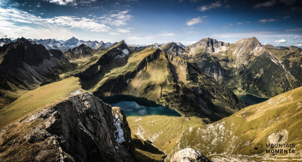
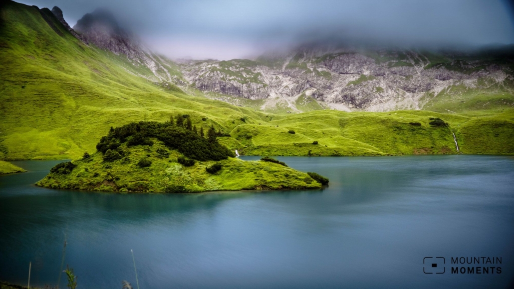
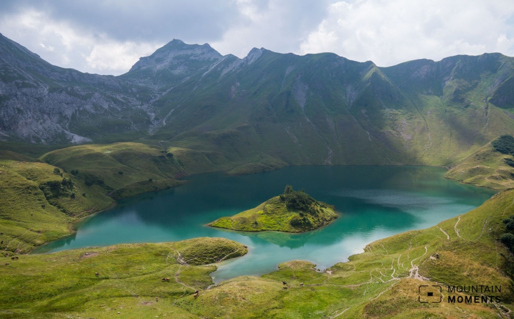
Schreck (Schrecksee) is probably undisputedly the most beautiful mountain lake in the German Alps. Nestled in meadow slopes and decorated with a small island, lake Schreck is a special idyll in the Allgäu Alps. Somewhat hidden in the Allgäu High Alps nature reserve, the mountain village of Hinterstein has retained its original character and charm, making it definitely worth a side trip.
Route description – this is how your Schreck-driven route looks like on a map
The hike start is in Hinterstein “Auf der Höh” (885m). Directly at the parking lot, turn left and gently follow the alpine road uphill (direction Willersalpe) to its end. Now continue along the hiking trail to the Willersalpe. After a short rest, take the jubilee path to the right, ascending over a few hairpin bends to the Vordere Schafwanne (2057m).
Here at the transition it is recommended to additionally climb the Gaishorn (2247m) to the left uphill. Back at the saddle follow the jubilee path further over the Hintere Schafwanne (1965m) until you see and subsequently reach the Schreck. From the lake, the hiking trail goes directly down into the Taufersbach valley and logically leads to the road and bus stop of E-Werk/Auele.
From here you can take a bus or continue on foot along the road back to the starting point.
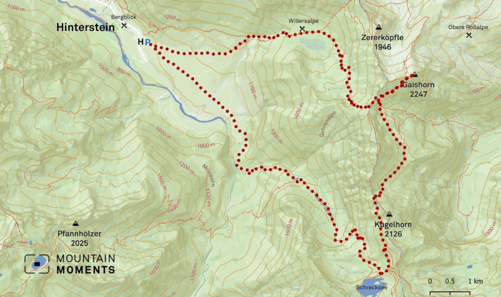
Photo tips that will make your Instagram pop – unbelievably pretty Schrecksee lake
The main photo spot is of course the Schrecksee: close to the shore or from one of the surrounding hills we can create the most beautiful shots. If possible, make sure that the island in the lake is easily recognizable as an island.
The view from the Gaishorn and the many small beauties along the way in this idyllic and unspoiled mountain and alpine landscape also offer themselves to us for photographing.
Mountain Moments Photo Workshops provide Photo Tours for everybody, Alpine Experience for beginners and intermediate-level photographers with 3 to 6-hour routes, as well as Summit Experience for more advanced photographers and hikers. We have private workshops and group classes.
More information about your backpacking tour on the Bavarian Alps
How to get there by public transport: first take a train to Sonthofen, then continue by bus to Bad Hindelang, from there change to direction Hinterstein Kraftwerk Auele (937m), reachable by bus (Giebelhausbus) from Hinterstein, www.wechs.net.
How to get there by car: use B19 to Sonthofen, continue on the B308 in the direction of Bad Hindelang, from there to Hinterstein, parking lot Auf der Höh in Hinterstein.
Start/finish: Hinterstein, Auf der Höh (885m) 47.474313,10.416601
Distance: 20km
Duration: 9h
Ascent/descent: 1600m/1600m
Highest point/lowest point: 900m/2247m
Hike difficulty level: difficult
Special features: Partly rope-secured, surefootedness necessary. After Widdersalpe no refreshment possibility on the way.
Catering: Willersalpe, Auf der Höh, Hinterstein.
Further tips: A nice two-day tour leads via the Vilsalpsee and the Landsberger Hütte in a circular route.
Contact: www.hinterstein.de
The most beautiful photo spots and hikes in the Alps – experience this hiking tour and 29 other exceptional regions now.
 Fancy more hikes in the mountains – and beautiful photos? Get out into nature! Experience the best hikes and locations with our new book: Alps – Photo and Hiking Guide. The 90 best Photo Locations and 30 most panoramic Hikes.
Here we have compiled the most beautiful locations and photo opportunities. 30 hikes with 90 photo spots are selected and described in such a way that you can easily experience these wonderful landscapes for yourself – including GPS tracks and hiking map and all other information. ie schönsten Orte und Fotogelegenheiten in den Bergen zusammengefasst. 30 Wanderungen mit 95 Fotospots sind so ausgewählt und beschrieben, dass auch du diese wunderbaren Landschaften selbst erleben kannst – inkl. GPS Tracks und Wanderkarte und allen weiteren Infos.
You can take a closer look at the ebook here– – why not give it as a gift to someone you want to visit and photograph these places with!
Of course, you will find all the information about this hike in the ebook. After registering, you will also receive the GPS track, so you are on the safe side and won’t get lost and will find all photo locations easily.


