Tag Archive for: Hiking Map
 https://www.mountainmoments.com/wp-content/uploads/2021/07/Mountain-Moments-Wanderung-Nockspitze-Hiking-Gorgeous-Sunrise-Photography-Main.jpeg
1335
2000
Marius
https://www.mountainmoments.com/wp-content/uploads/2023/07/MM_Logo_180-width.png
Marius2023-05-19 18:34:002023-04-18 17:44:44Dazzling Daybreak! Catch the Gorgeous Sunrise Aura on Nockspitze Hike
https://www.mountainmoments.com/wp-content/uploads/2021/07/Mountain-Moments-Wanderung-Nockspitze-Hiking-Gorgeous-Sunrise-Photography-Main.jpeg
1335
2000
Marius
https://www.mountainmoments.com/wp-content/uploads/2023/07/MM_Logo_180-width.png
Marius2023-05-19 18:34:002023-04-18 17:44:44Dazzling Daybreak! Catch the Gorgeous Sunrise Aura on Nockspitze Hike https://www.mountainmoments.com/wp-content/uploads/2021/07/Mountain-Moments-railrun-Almenweg-Patsch-Hiking-Running-Route-Main-Photography.jpeg
1335
2000
Marius
https://www.mountainmoments.com/wp-content/uploads/2023/07/MM_Logo_180-width.png
Marius2023-05-11 19:08:002023-04-05 19:06:32Run 30k Patscherkofel Mountain Trail along 1000-Y-Old Pine Trees
https://www.mountainmoments.com/wp-content/uploads/2021/07/Mountain-Moments-railrun-Almenweg-Patsch-Hiking-Running-Route-Main-Photography.jpeg
1335
2000
Marius
https://www.mountainmoments.com/wp-content/uploads/2023/07/MM_Logo_180-width.png
Marius2023-05-11 19:08:002023-04-05 19:06:32Run 30k Patscherkofel Mountain Trail along 1000-Y-Old Pine Trees https://www.mountainmoments.com/wp-content/uploads/2021/07/Mountain-Moments-Wanderung-Sellrainer-Huttentour-Hiking-Route-Photography-Main.jpeg
1335
2000
Marius
https://www.mountainmoments.com/wp-content/uploads/2023/07/MM_Logo_180-width.png
Marius2023-05-07 19:09:002023-04-05 18:50:00Sellrain Multi-Day-Trek – Discover untouched nature in Austrian Alps
https://www.mountainmoments.com/wp-content/uploads/2021/07/Mountain-Moments-Wanderung-Sellrainer-Huttentour-Hiking-Route-Photography-Main.jpeg
1335
2000
Marius
https://www.mountainmoments.com/wp-content/uploads/2023/07/MM_Logo_180-width.png
Marius2023-05-07 19:09:002023-04-05 18:50:00Sellrain Multi-Day-Trek – Discover untouched nature in Austrian Alps https://www.mountainmoments.com/wp-content/uploads/2021/07/Mountain-Moments-Mountaineering-Bergsteigen-Wilder-Freiger-Hiking-Route-Photography-Main.jpeg
1335
2000
Marius
https://www.mountainmoments.com/wp-content/uploads/2023/07/MM_Logo_180-width.png
Marius2023-04-28 19:01:002023-03-31 19:15:08Hut above a Glacier Spot: Amazing Becherhaus – High Alpine Hiking Tour Stubai Alps
https://www.mountainmoments.com/wp-content/uploads/2021/07/Mountain-Moments-Mountaineering-Bergsteigen-Wilder-Freiger-Hiking-Route-Photography-Main.jpeg
1335
2000
Marius
https://www.mountainmoments.com/wp-content/uploads/2023/07/MM_Logo_180-width.png
Marius2023-04-28 19:01:002023-03-31 19:15:08Hut above a Glacier Spot: Amazing Becherhaus – High Alpine Hiking Tour Stubai Alps https://www.mountainmoments.com/wp-content/uploads/2021/07/Mountain-Moments-Karwendel-Route-Map-Hiking-Photography-Main-Image-2.jpeg
1333
2000
Marius
https://www.mountainmoments.com/wp-content/uploads/2023/07/MM_Logo_180-width.png
Marius2023-04-11 16:29:002023-03-31 15:26:48Epic Multi-Day Hike from Innsbruck – Karwendel Crossing in the Northern Limestone Alps
https://www.mountainmoments.com/wp-content/uploads/2021/07/Mountain-Moments-Karwendel-Route-Map-Hiking-Photography-Main-Image-2.jpeg
1333
2000
Marius
https://www.mountainmoments.com/wp-content/uploads/2023/07/MM_Logo_180-width.png
Marius2023-04-11 16:29:002023-03-31 15:26:48Epic Multi-Day Hike from Innsbruck – Karwendel Crossing in the Northern Limestone Alps https://www.mountainmoments.com/wp-content/uploads/2021/07/Mountain-Moments-Trailrun-Eichhoftrail-Hiking-Route-Mountain-Run.jpeg
1332
2000
Marius
https://www.mountainmoments.com/wp-content/uploads/2023/07/MM_Logo_180-width.png
Marius2023-04-10 19:07:002023-04-05 19:25:52Alpine Run on a 9-Kilometer Innsbruck’s Eichhoftrail – Map, Tips, and Video!
https://www.mountainmoments.com/wp-content/uploads/2021/07/Mountain-Moments-Trailrun-Eichhoftrail-Hiking-Route-Mountain-Run.jpeg
1332
2000
Marius
https://www.mountainmoments.com/wp-content/uploads/2023/07/MM_Logo_180-width.png
Marius2023-04-10 19:07:002023-04-05 19:25:52Alpine Run on a 9-Kilometer Innsbruck’s Eichhoftrail – Map, Tips, and Video! https://www.mountainmoments.com/wp-content/uploads/2022/02/Geigelstein-Hiking-Route-Map-Mountain-Moments-Photography-Workshops-Gallery-2.jpeg
1332
2000
Marius
https://www.mountainmoments.com/wp-content/uploads/2023/07/MM_Logo_180-width.png
Marius2023-03-25 18:26:002023-03-18 11:31:53Hiking in Geigelstein! Enjoy and Capture Fabulous Panoramic Views
https://www.mountainmoments.com/wp-content/uploads/2022/02/Geigelstein-Hiking-Route-Map-Mountain-Moments-Photography-Workshops-Gallery-2.jpeg
1332
2000
Marius
https://www.mountainmoments.com/wp-content/uploads/2023/07/MM_Logo_180-width.png
Marius2023-03-25 18:26:002023-03-18 11:31:53Hiking in Geigelstein! Enjoy and Capture Fabulous Panoramic Views https://www.mountainmoments.com/wp-content/uploads/2022/02/Iseler-Hiking-Route-Mountain-Moments-Workshop-Photo-Gallery-4.jpeg
1800
1200
Marius
https://www.mountainmoments.com/wp-content/uploads/2023/07/MM_Logo_180-width.png
Marius2023-03-19 15:36:002023-03-17 19:57:47Panoramic Via Ferrata Hike at Iseler! Explore Photo Opportunities on Three Summits
https://www.mountainmoments.com/wp-content/uploads/2022/02/Iseler-Hiking-Route-Mountain-Moments-Workshop-Photo-Gallery-4.jpeg
1800
1200
Marius
https://www.mountainmoments.com/wp-content/uploads/2023/07/MM_Logo_180-width.png
Marius2023-03-19 15:36:002023-03-17 19:57:47Panoramic Via Ferrata Hike at Iseler! Explore Photo Opportunities on Three Summits https://www.mountainmoments.com/wp-content/uploads/2022/02/Fellhornkamm-Mountain-Moments-Photography-Hiking-Guide-2.jpeg
1332
2000
Marius
https://www.mountainmoments.com/wp-content/uploads/2023/07/MM_Logo_180-width.png
Marius2023-03-18 15:19:002023-03-17 19:58:03Fellhorn Summit – Panoramic ridge hike near Oberstdorf! Route Map & Photography Tips
https://www.mountainmoments.com/wp-content/uploads/2022/02/Fellhornkamm-Mountain-Moments-Photography-Hiking-Guide-2.jpeg
1332
2000
Marius
https://www.mountainmoments.com/wp-content/uploads/2023/07/MM_Logo_180-width.png
Marius2023-03-18 15:19:002023-03-17 19:58:03Fellhorn Summit – Panoramic ridge hike near Oberstdorf! Route Map & Photography Tips https://www.mountainmoments.com/wp-content/uploads/2022/02/Schafreuter-Sylvenstein-Hiking-Route-Map-Mountain-Photography-Workshops-Gallery-4.jpeg
1335
2000
Marius
https://www.mountainmoments.com/wp-content/uploads/2023/07/MM_Logo_180-width.png
Marius2023-03-16 14:56:492023-03-29 14:28:32Hike the Schafreuter Peak and Capture the Insta Spot Sylvenstein Lake! Reasons to Visit Karwendel Nature Park
https://www.mountainmoments.com/wp-content/uploads/2022/02/Schafreuter-Sylvenstein-Hiking-Route-Map-Mountain-Photography-Workshops-Gallery-4.jpeg
1335
2000
Marius
https://www.mountainmoments.com/wp-content/uploads/2023/07/MM_Logo_180-width.png
Marius2023-03-16 14:56:492023-03-29 14:28:32Hike the Schafreuter Peak and Capture the Insta Spot Sylvenstein Lake! Reasons to Visit Karwendel Nature Park https://www.mountainmoments.com/wp-content/uploads/2022/02/Hochstaufen-Route-Map-Mountain-Moments-Phtoography-Workshops-Gallery-3.jpeg
1332
2000
Marius
https://www.mountainmoments.com/wp-content/uploads/2023/07/MM_Logo_180-width.png
Marius2023-03-12 16:16:002023-03-11 15:52:26Hochstaufen Hiking Challenge! Map for a Difficult Trail in the Chiemgau Alps
https://www.mountainmoments.com/wp-content/uploads/2022/02/Hochstaufen-Route-Map-Mountain-Moments-Phtoography-Workshops-Gallery-3.jpeg
1332
2000
Marius
https://www.mountainmoments.com/wp-content/uploads/2023/07/MM_Logo_180-width.png
Marius2023-03-12 16:16:002023-03-11 15:52:26Hochstaufen Hiking Challenge! Map for a Difficult Trail in the Chiemgau Alps https://www.mountainmoments.com/wp-content/uploads/2022/02/Hochfelln-Hiking-Route-Map-Mountain-Moments-Photography-Workshop-Gallery-2.jpeg
1333
2000
Marius
https://www.mountainmoments.com/wp-content/uploads/2023/07/MM_Logo_180-width.png
Marius2023-03-12 15:06:002023-03-11 15:55:55Hochfelln Hike! Astonishing scenic views at Hochfelln Hut in the Chiemgau Alps + all infos
https://www.mountainmoments.com/wp-content/uploads/2022/02/Hochfelln-Hiking-Route-Map-Mountain-Moments-Photography-Workshop-Gallery-2.jpeg
1333
2000
Marius
https://www.mountainmoments.com/wp-content/uploads/2023/07/MM_Logo_180-width.png
Marius2023-03-12 15:06:002023-03-11 15:55:55Hochfelln Hike! Astonishing scenic views at Hochfelln Hut in the Chiemgau Alps + all infos https://www.mountainmoments.com/wp-content/uploads/2022/02/Kampenwand-Hiking-Route-Mountain-Moments-Photography-Workshop-Gallery-1.jpeg
1333
2000
Marius
https://www.mountainmoments.com/wp-content/uploads/2023/07/MM_Logo_180-width.png
Marius2023-03-11 14:00:012023-03-16 16:06:28Kampenwand Hike! Easy hike for families and photrographers alike! Photograph Jagged Rock Ridges
https://www.mountainmoments.com/wp-content/uploads/2022/02/Kampenwand-Hiking-Route-Mountain-Moments-Photography-Workshop-Gallery-1.jpeg
1333
2000
Marius
https://www.mountainmoments.com/wp-content/uploads/2023/07/MM_Logo_180-width.png
Marius2023-03-11 14:00:012023-03-16 16:06:28Kampenwand Hike! Easy hike for families and photrographers alike! Photograph Jagged Rock Ridges https://www.mountainmoments.com/wp-content/uploads/2022/02/Kneefelspitze-Hiking-Route-Map-Mountain-Moments-Photography-Workshops-Gallery-1.jpeg
1061
1600
Marius
https://www.mountainmoments.com/wp-content/uploads/2023/07/MM_Logo_180-width.png
Marius2022-03-13 16:18:002023-03-16 14:45:44Scenic Hike on Picturesque Kneifelspitze – A great view in Berchtesgaden
https://www.mountainmoments.com/wp-content/uploads/2022/02/Kneefelspitze-Hiking-Route-Map-Mountain-Moments-Photography-Workshops-Gallery-1.jpeg
1061
1600
Marius
https://www.mountainmoments.com/wp-content/uploads/2023/07/MM_Logo_180-width.png
Marius2022-03-13 16:18:002023-03-16 14:45:44Scenic Hike on Picturesque Kneifelspitze – A great view in Berchtesgaden https://www.mountainmoments.com/wp-content/uploads/2021/07/Mountain-Moments-Innsbruck-Nordkette-Via-Ferrata-Ridge-Photography-8-2.jpeg
1333
2000
Marius
https://www.mountainmoments.com/wp-content/uploads/2023/07/MM_Logo_180-width.png
Marius2021-09-20 20:51:012021-09-20 20:51:12Innsbruck-Nordkette Via Ferrata Ridge Hike – Photo Gallery From the Eastern Alps
https://www.mountainmoments.com/wp-content/uploads/2021/07/Mountain-Moments-Innsbruck-Nordkette-Via-Ferrata-Ridge-Photography-8-2.jpeg
1333
2000
Marius
https://www.mountainmoments.com/wp-content/uploads/2023/07/MM_Logo_180-width.png
Marius2021-09-20 20:51:012021-09-20 20:51:12Innsbruck-Nordkette Via Ferrata Ridge Hike – Photo Gallery From the Eastern Alps https://www.mountainmoments.com/wp-content/uploads/2021/06/Mountain-Moments-Pian-di-Cengia-On-Hiking-Route-Map-Photography-Amazing-Main-Image.jpeg
1800
1202
Marius
https://www.mountainmoments.com/wp-content/uploads/2023/07/MM_Logo_180-width.png
Marius2021-08-04 16:48:082021-08-04 16:48:17Pian di Cengia – Quiet Alpine Hiking Paths With Photos That Scream Beauty
https://www.mountainmoments.com/wp-content/uploads/2021/06/Mountain-Moments-Pian-di-Cengia-On-Hiking-Route-Map-Photography-Amazing-Main-Image.jpeg
1800
1202
Marius
https://www.mountainmoments.com/wp-content/uploads/2023/07/MM_Logo_180-width.png
Marius2021-08-04 16:48:082021-08-04 16:48:17Pian di Cengia – Quiet Alpine Hiking Paths With Photos That Scream Beauty https://www.mountainmoments.com/wp-content/uploads/2021/06/Mountain-Moments-Mont-Blanc-Courmayer-Route-Photography-Hiking.jpeg
1335
2000
Marius
https://www.mountainmoments.com/wp-content/uploads/2023/07/MM_Logo_180-width.png
Marius2021-08-04 10:50:452021-08-04 10:52:27Panoramic Hike in Val Ferret – Photograph the Sunny Side of Mont Blanc near Courmayeur
https://www.mountainmoments.com/wp-content/uploads/2021/06/Mountain-Moments-Mont-Blanc-Courmayer-Route-Photography-Hiking.jpeg
1335
2000
Marius
https://www.mountainmoments.com/wp-content/uploads/2023/07/MM_Logo_180-width.png
Marius2021-08-04 10:50:452021-08-04 10:52:27Panoramic Hike in Val Ferret – Photograph the Sunny Side of Mont Blanc near Courmayeur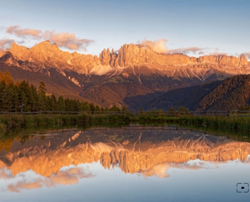 https://www.mountainmoments.com/wp-content/uploads/2021/06/Mountain-Moments-Wuhnleger-Weiher-Grundkarte-Small-Pond-Photography.jpeg
1233
2000
Marius
https://www.mountainmoments.com/wp-content/uploads/2023/07/MM_Logo_180-width.png
Marius2021-07-19 06:31:592022-07-20 08:07:54Your Light Rosengarten Backpacking – Photo Spot Wuhnleger Lake Mirrors Red Mountain Peaks
https://www.mountainmoments.com/wp-content/uploads/2021/06/Mountain-Moments-Wuhnleger-Weiher-Grundkarte-Small-Pond-Photography.jpeg
1233
2000
Marius
https://www.mountainmoments.com/wp-content/uploads/2023/07/MM_Logo_180-width.png
Marius2021-07-19 06:31:592022-07-20 08:07:54Your Light Rosengarten Backpacking – Photo Spot Wuhnleger Lake Mirrors Red Mountain Peaks https://www.mountainmoments.com/wp-content/uploads/2021/06/Mountain-Moments-Hiking_Map_Sellastock-Uberschreitung-Amazing-Landscape-Wide-Main.jpeg
1335
2000
Ina
https://www.mountainmoments.com/wp-content/uploads/2023/07/MM_Logo_180-width.png
Ina2021-07-14 10:25:452021-07-14 10:25:52Demanding Sella Massif Climb – Use Piz Boè Peak as Photography Vantage Point
https://www.mountainmoments.com/wp-content/uploads/2021/06/Mountain-Moments-Hiking_Map_Sellastock-Uberschreitung-Amazing-Landscape-Wide-Main.jpeg
1335
2000
Ina
https://www.mountainmoments.com/wp-content/uploads/2023/07/MM_Logo_180-width.png
Ina2021-07-14 10:25:452021-07-14 10:25:52Demanding Sella Massif Climb – Use Piz Boè Peak as Photography Vantage Point https://www.mountainmoments.com/wp-content/uploads/2021/06/Mountain-Moments-Pragser-Wildsee-Lake-Hiking-Route-Photography-Main.jpeg
1800
1440
Marius
https://www.mountainmoments.com/wp-content/uploads/2023/07/MM_Logo_180-width.png
Marius2021-07-13 16:00:092021-07-13 16:00:16Is Lago di Braies the Most Beautiful Lake in Italy? Backpack along the lake and Find Out
https://www.mountainmoments.com/wp-content/uploads/2021/06/Mountain-Moments-Pragser-Wildsee-Lake-Hiking-Route-Photography-Main.jpeg
1800
1440
Marius
https://www.mountainmoments.com/wp-content/uploads/2023/07/MM_Logo_180-width.png
Marius2021-07-13 16:00:092021-07-13 16:00:16Is Lago di Braies the Most Beautiful Lake in Italy? Backpack along the lake and Find Out