Hiker’s Bucket List – Reach the Edge of the Dolomites on Peitlerkofel Mountain
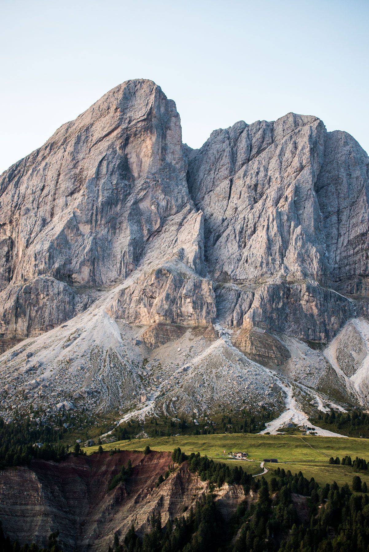
In South Tyrol, Italy, stretches the Peitlerkofel mountain, a hiker’s fantasy that, at its highest point, reaches out to the sky 2387 meters high. As a member of the mountain range Dolomites, this destination promises an unforgettable experience for hikers. One such popular route is covered here, so prepare your hiking equipment and get ready for this 5.5-hour joy hike (medium difficult).
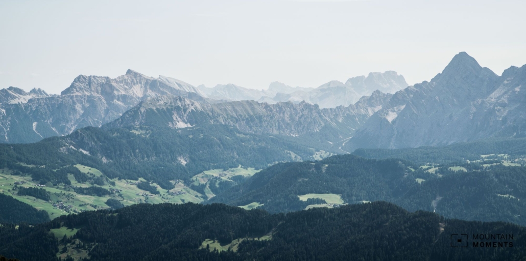
Massive steep faces and peripheral position in the Dolomites – the solitary Peitlerkofel (ital. Sas de Pütia) is a cornerstone of the Dolomites due to its position on the edge. The solitary position is also the biggest advantage for all hikers and photographers, who thus get a unique and wide view over the surrounding Dolomite mountains without a long climb.

The circumnavigation of the Peitlerkofel group includes both stony sections and natural meadows – at the right time of year in midsummer from the end of June, a diverse and rare flower splendor presents itself here. Those who are spontaneous and do not yet have burning thighs can climb one of the two Peitlerkofel peaks.
The 2813-meter-high secondary peak (Small Peitlerkofel), already offers a beautiful view and can be reached via a moderately difficult climb. To enjoy the 360° panoramic view, climb even higher up to the Peitlerkofel. The climb, which is similar to a via ferrata, is reserved for hikers who are sure-footed and free from vertigo.
Route description: this is how your amazing Peitlerkofel journey looks like on a map
At the Passo delle Erbe/Würzjoch take the easy and gently ascending forest path 8A through a sparse forest in the direction of the Fornella hut. Above the forest the path becomes an alpine path. This leads through the famous Peitler meadows.
At the crossroads near the Fornella hut, turn left, pass the hut and walk without much effort until you reach the Göma hut. Then head towards the Vaciara hut over the Gömajoch. Now continue along the high trail over the Kreuzkofeljoch (2340m) to the Schlüter hut (2306m). From here hike back the last passage of the outward route to the Kreuzkofeljoch.
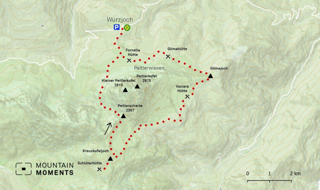
Here turn left slightly uphill (path no. 4) towards the Peitlerscharte (2357m). Here either branch off to the summit or turn left towards the Fornella Hut. The trail first runs parallel to the small Lasankenbach (stream) and then crosses the impressive northwest flank of the Peitlerkofel over a few mudslides.
Finally, across a meadow past the Fornella hut and continue to the starting point, the Passo delle Erbe/Würzjoch.
Alternative: For all those who want to reach the summit, it is recommended to ascend the small Peitlerkofel from the Peitlerscharte. For hikers with alpine experience and climbing skills in the first degree of difficulty, the via ferrata-like ascent to the Peitlerkofel is a worthwhile addition. Depending on the time of day, adapt the tour and, if in doubt, descend on the shorter ascent route.
Photo tips for Peitler meadows that will make your Instagram pop
Already at the beginning of the tour on the Peitlerwiesen there are various photo motifs. We recommend taking a picture of the Peitler meadows with the Peitlerkofel group in the background as the border of the picture.
Especially in the blooming season of the alpine roses from about mid-June to early August, unique flower shots are possible on the south side of the Peitlerkofel. We enjoy the rustic wooden huts with the surrounding meadows and the south face in the background.
Mountain Moments Photo Workshops provide Photo Tours for everybody, Alpine Experience for beginners and intermediate-level photographers with 3 to 6-hour routes, as well as Summit Experience for more advanced photographers and hikers. We have private workshops and group classes.
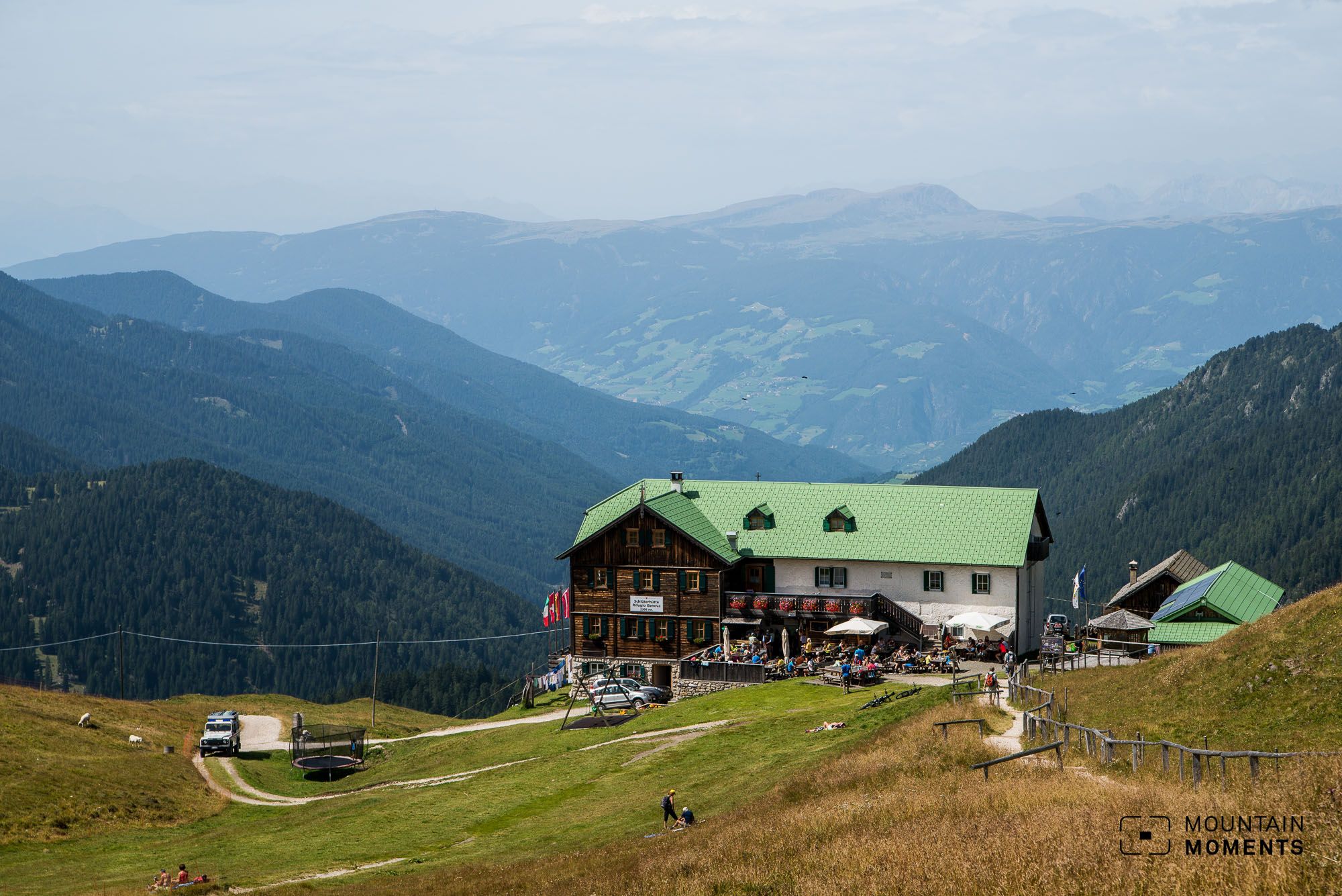
When climbing one of the two peaks of the Peitlerkofel, the panoramic shots from the Marmolada to the Zillertal Alps are of course a must. At the Schlüter hut we photograph the most panoramic from a little above.
It is considered one of the most beautiful huts in the Dolomites. House-smoked bacon and homemade apple strudel give the tired photographers new strength.
Information on how to join Peitlerkofel mountain hike
Getting there on foot: Take the Brenner freeway to the Brixen/Vahrn exit and follow the Pustertal state road SS49 to St. Lorenzen. Continue on the Gadertaler state road SS244 to St. Martin in Thurn and there to the Würzjoch (parking lot subject to charges).
How to get there by public transport: By train to Bruneck. Then change to the regional bus to Pikolein/Piculin and from there take the bus (e.g. line 464) to the Würzjoch.
Hike difficulty level: medium
Duration/distance: 5.5h/16.2km
Ascent/descent: 620hm/620hm
Highest/lowest point: 2387m/1996m
Refreshments: Fornella hut, Göma hut, Vaciara hut, Schlüter hut (Rifugio Genova)
Start/finish: Passo delle Erbe/Würzjoch (coordinates: geogr. 46.675090, 11.814402)
The most beautiful photo spots and hikes in the Dolomites – experience this hiking tour and 29 other exceptional trips in the Dolomites now.
 Fancy more hikes in the mountains – and beautiful photos? Get out into nature! Experience the best hikes and locations with our new book: Alps – Photo and Hiking Guide. The 90 best Photo Locations and 30 most panoramic Hikes.
Here we have compiled the most beautiful locations and photo opportunities. 30 hikes with 90 photo spots are selected and described in such a way that you can easily experience these wonderful landscapes for yourself – including GPS tracks and hiking map and all other information.
You can take a closer look at the ebook here– – why not give it as a gift to someone you want to visit and photograph these places with!
Of course, you will find all the information about this hike in the ebook. After registering, you will also receive the GPS track, so you are on the safe side and won’t get lost and will find all photo locations easily.

Hi, i am Marius, i love exploring the mountains and nature. Friends say, i know the mountains better than most locals, but actually i get lost all the time while photographing ;). Read more about the Mountain Moments Team.


