Panoramic Hike in Val Ferret – Photograph the Sunny Side of Mont Blanc near Courmayeur
On a stretch of valleys known to many hikers and photographers as Val Ferret, southeast of Mont Blanc Massif, you can find your ticket to the sights and feelings no movie theatre would be able to provide or reproduce. Here we cover one very popular hiking route that will give you a chance to photograph Dent du Géant and Mont Blanc until your camera battery dies and shutter-release button falls off. Are you ready? We are, so join us!
Hiking the Alps from hut to hut is the dream of many hiking enthusiasts. Among the myriad of possibilities, the “Tour du Mont Blanc” is probably the most famous hut trek in the Alps. The long-distance trail winds around the massif of Mont Blanc, crossing Italian, Swiss and French territory.
Ambitious mountain runners cover approximately 170 kilometers and 10,000 meters of altitude in under 24 hours. An average hiker is more likely to take 7-11 days, giving him more time to enjoy the austere-looking rock faces, menacing-looking glaciers, miles of ice moraines, pastures, and alpine meadows.


Directions! This is how your Val Ferret route looks like on a map
From the center of Courmayeur at Piazza Abbé Henry (Church of San Pantaleone, 1225m) uphill the Strada del Villair. Follow the road until the parking lot/end of the public road. Follow the road for a few meters, turn left over the bridge and at the next but one bend turn left onto trail no. 42 towards Bertone Refuge (Rifugio Bertone 1979m).
The path crosses the road twice and leads steeply in some hairpin bends to Bertone Refuge. Continue uphill past the hut and turn left at the junction. Here now moderately difficult towards the high trail along the slope labeled “TMB” to Refuge Walter Bonatti (2025m).
After a well-deserved break, continue along the path/TMB over a stream and after about 200m turn left downhill towards Lavachey into Val Ferret. In Val Ferret finally about 3km along the road downhill to the parking lot in Plampincieux and by bus (“Allô Bus”, www.savda.it on call or cab) back to Courmayeur.

Photo tips that will make your Instagram pop – Aiguille du Midi, Dent du Geants and the view of Mont Blanc from Val Ferret

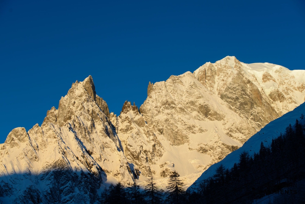
At the Skyway Monte Bianco glacier station, don’t miss the deep view to Courmayeur, towards Aiguille du Midi and especially to Dent du Geants. The most beautiful photo here often has the striking and unmistakable granite needle Dent du Géant in the upper third of the picture as a formative element. From Bertone Refuge, the hike offers a wonderful frontal view of the Mont Blanc south face and leads picturesquely through gentle meadows along the timberline.

Mountain Moments Photo Workshops provide Photo Tours for everybody, Alpine Experience for beginners and intermediate-level photographers with 3 to 6-hour routes, as well as Summit Experience for more advanced photographers and hikers. We have private workshops and group classes.

More information about your next hiking adventure in Courmayeur
How to get there by public transport: Via Milan by train to Aosta, here continue by bus to Courmayeur center. From here by foot or by bus 947 (savda.it) to the Sapin Valley. Alternatively bus from Chamonix or from Switzerland via Martigny, Sembrancher, Orsieres by bus to Aosta.
How to get there by car: From Milan take the E25 through the Aosta Valley. In Courmayeur center turn northeast on Strada Villair towards Val Sapin. Parking is at the end of the road. Alternatively from Chamonix via the Mont Blanc tunnel or from Switzerland via Martigny, the St. Bernard Pass and Aosta.
Start/finish: Courmayeur 45.791652,6.972531 / finish: Val Ferret-Plampincieux parking 45.831021,6.986009
Distance: 13,8km
Duration: 5:20h
Ascent/descent: 960m/590m
Highest point/lowest point: 1220m/2040m
Hike difficulty level: medium/difficult
Special features: Bus savda.it (Allô bus from/to Val Ferret until about 18.15, 0039 0165 1854653), cab www.courmayeurmontblanc.it.
Catering: Various in Courmayeur, Rifugio Bertone, Rifugio Walter Bonatti, Ristorante Lavachey, Plampincieux.
Other tips: Sightseeing at Punta Helbronner via Skyway Monte Bianco cable car. Gondola ride to Aiguille du Midi possible.
Contact: www.courmayeurmontblanc.it
The most beautiful photo spots and hikes in the Alps – experience this hiking tour and 29 other exceptional regions now.
 Fancy more hikes in the mountains – and beautiful photos? Get out into nature! Experience the best hikes and locations with our new book: Alps – Photo and Hiking Guide. The 90 best Photo Locations and 30 most panoramic Hikes.
Here we have compiled the most beautiful locations and photo opportunities. 30 hikes with 90 photo spots are selected and described in such a way that you can easily experience these wonderful landscapes for yourself – including GPS tracks and hiking map and all other information.
You can take a closer look at the ebook here – why not give it as a gift to someone you want to visit and photograph these places with!
Of course, you will find all the information about this hike in the ebook. After registering, you will also receive the GPS track, so you are on the safe side and won’t get lost and will find all photo locations easily.

Hi, i am Marius, i love exploring the mountains and nature. Friends say, i know the mountains better than most locals, but actually i get lost all the time while photographing ;). Read more about the Mountain Moments Team.


