
Challenging Watzmann Hike! Royal Tour on Germany’s Third Highest Mountain over Hocheck Hut
South of the village of Berchtesgaden, in the Bavarian Alps, a difficult 24-kilometer hiking trail treats you with an Alpine tour of marvelously gigantic proportions. Hiking on the Watzmann mountain will take up your entire day, and you certainly want to be there for sunrises and sunsets.
To plan accordingly, Mountain Moments brings you the most important information about the location, including map, expert hiking tips, and photography workshops. If you are experienced and willing, grab your hiking equipment, reach out, and share the amazing experience with the crew.
What’s so special about this hiking route? This is what awaits you on the location
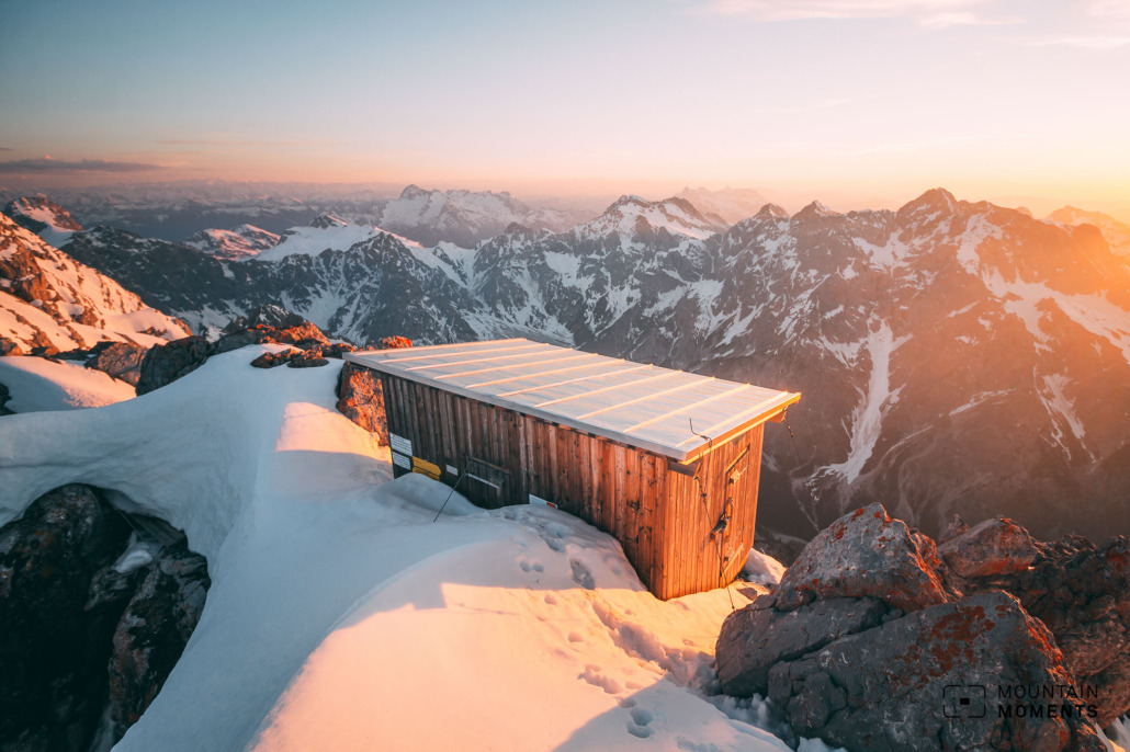
The Watzmann is the classic in the Berchtesgaden Alps. The tripartite summit structure (Hocheck 2,651m – Mittelspitze 2,713m – Südspitze 2,712m) with the massive eastern flank is both impressive and challenging. The east flank is one of the largest walls in the Eastern Alps!
If you are not (yet) a summit pro, the best way to photograph the east face is on a leisurely boat tour on the Königssee. From St. Bartholomä we can also reach a fantastic ice grotto in a few minutes. This invites you to photographic exploration (caution: danger of collapse).
Anyone who embarks on the adventure of crossing the Watzmann will be rewarded with extraordinary views and descent of almost 2000 meters in one go with burning calves.

Directions! This is how your Watzmann hiking trail looks like on a map
The starting point is at the inn/bus stop Wimbachklamm. First always uphill, mostly on the road towards Watzmannn-Haus (1915m). From here, the path becomes steeper and more difficult to the Hocheck summit (emergency bivouac, 2657m). This is the last meaningful reversal point.
Here we climb the Zackengrat via Ferrata (via Ferrata A/B, partly unsecured). It goes with some ups and downs – sometimes to the east, mostly to the west of the ridge – along the Mittelspitze (2713m) to the Südspitze (2712m).
After the southern summit, the path leads continuously downhill to the Wimbachgries hut. From here we follow the road logically for many kilometers back to Gasthof Wimbachklamm.
The tour is often planned to be spread over two days – an overnight stay in the Watzmann house.
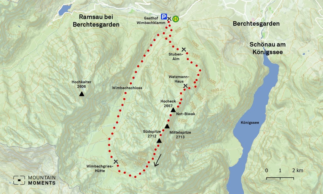
Easier alternatives are the hike only to the Watzmann-Haus or to the Hocheck bivouac (2657m).
Photo tips that will make your Instagram pop! Ice grotto and spectacular motifs
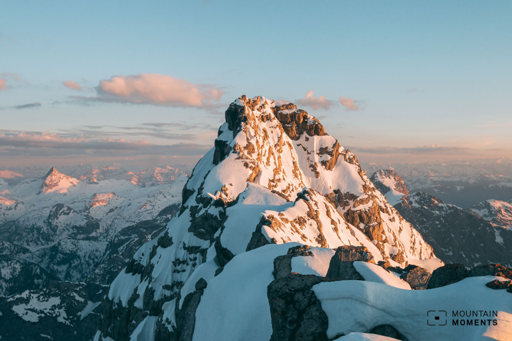
This high Alpine tour is very demanding for many climbers. You can photograph the majestic eastern flank of the Watzmann from the boat tour on Königssee. Here you will also be awarded by an ice grotto with the opportunity to take atmospheric photos.
Mountain Moments Photo Workshops provide Photo Tours for everybody, Alpine Experience for beginners and intermediate-level photographers with 3 to 6-hour routes, as well as Summit Experience for more advanced photographers and hikers. We have private workshops and group classes.
On the tour itself, the outstanding view is a highlight, especially in the early hours of the morning (climbers often start in the dark of night and plan to climb the summit for sunrise). The mountaineers on the ridge as a detail or landscape shot are also spectacular motifs.
More information about your hiking adventure – from arrival to the finish line
Getting there: From Bad Reichenhall via the B20 and B305 to the Wimbach Bridge. Alternatively A8 exit Traunstein/Siegsdorf and on B305 via Inzell and Schneizlreuth to Wimbachbrücke. Wimbachklamm car park (chargeable).
Public transportation: From Berchtesgarden Bus to the Wimbachklamm stop.
Difficulty: difficult (!)
Duration: 10h, 24km
Ascent/descent: 2380m/2380m
Highest/lowest point: 1512m/630m
stop: Watzmann-Haus, Wimbachgries Hütte, Gasthof Wimbachklamm
Start/finish: Berchtesgaden Wimbachklamm (coordinates: geogr. 47.602268, 12.924327)
Particular dangers: No continuous via Ferrata. Absolute sure-footedness and a head for heights as well as the ability to walk in open, high-alpine terrain are necessary. Long tour, therefore good tour planning (food) is essential.
Tips: Easier alternatives are the hike only to the Watzmannhaus or to the Hocheck bivouac (2657m).
The most beautiful photo spots and hikes in the German Alps – experience this hiking tour and 29 other exceptional regions now.

Fancy more hikes in the mountains – and beautiful photos? Get out into nature! Experience the best hikes and locations with our new book: German Alps – Photo and Hiking Guide. The 90 best Photo Locations and 30 most panoramic Hikes.
Here we have compiled the most beautiful locations and photo opportunities. 30 hikes with 90 photo spots are selected and described in such a way that you can easily experience these wonderful landscapes in Bavaria for yourself – including GPS tracks and hiking map and all other information.
You can take a closer look at the ebook here– – why not give it as a gift to someone you want to visit and photograph these places with!
Of course, you will find all the information about this hike in the ebook. You als get the GPS track of this trail, so you are on the safe side and won’t get lost and will find all photo locations easily.
Feel invited to comment when you have finished this hike, thanks.

Hi, i am Marius, i love exploring the mountains and nature. Friends say, i know the mountains better than most locals, but actually i get lost all the time while photographing ;). Read more about the Mountain Moments Team.


