Tag Archive for: Mountain Photography
 https://www.mountainmoments.com/wp-content/uploads/2021/07/Mountain-Moments-Trailrun-Ultra-Trail-Hiking-Biking-Route-Photography-Main.jpeg
1300
2000
Ina
https://www.mountainmoments.com/wp-content/uploads/2023/07/MM_Logo_180-width.png
Ina2021-08-04 10:04:002023-03-30 17:08:21Innsbruck Ultra Trail – Epic 70-Kilometer Trail-Run Around Innsbruck
https://www.mountainmoments.com/wp-content/uploads/2021/07/Mountain-Moments-Trailrun-Ultra-Trail-Hiking-Biking-Route-Photography-Main.jpeg
1300
2000
Ina
https://www.mountainmoments.com/wp-content/uploads/2023/07/MM_Logo_180-width.png
Ina2021-08-04 10:04:002023-03-30 17:08:21Innsbruck Ultra Trail – Epic 70-Kilometer Trail-Run Around Innsbruck https://www.mountainmoments.com/wp-content/uploads/2021/06/Mountain-Moments-Lake-Bled-Slovenia-Hiking-Tour-Wide-Angle-Photography-1.jpeg
1263
2000
Marius
https://www.mountainmoments.com/wp-content/uploads/2023/07/MM_Logo_180-width.png
Marius2021-08-03 16:53:112021-08-03 16:53:19Easy Hike to Lake Bled Viewpoint – the Most Photographed Attraction of the Slovenian Alps
https://www.mountainmoments.com/wp-content/uploads/2021/06/Mountain-Moments-Lake-Bled-Slovenia-Hiking-Tour-Wide-Angle-Photography-1.jpeg
1263
2000
Marius
https://www.mountainmoments.com/wp-content/uploads/2023/07/MM_Logo_180-width.png
Marius2021-08-03 16:53:112021-08-03 16:53:19Easy Hike to Lake Bled Viewpoint – the Most Photographed Attraction of the Slovenian Alps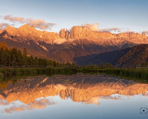 https://www.mountainmoments.com/wp-content/uploads/2021/06/Mountain-Moments-Wuhnleger-Weiher-Grundkarte-Small-Pond-Photography.jpeg
1233
2000
Marius
https://www.mountainmoments.com/wp-content/uploads/2023/07/MM_Logo_180-width.png
Marius2021-07-19 06:31:592022-07-20 08:07:54Your Light Rosengarten Backpacking – Photo Spot Wuhnleger Lake Mirrors Red Mountain Peaks
https://www.mountainmoments.com/wp-content/uploads/2021/06/Mountain-Moments-Wuhnleger-Weiher-Grundkarte-Small-Pond-Photography.jpeg
1233
2000
Marius
https://www.mountainmoments.com/wp-content/uploads/2023/07/MM_Logo_180-width.png
Marius2021-07-19 06:31:592022-07-20 08:07:54Your Light Rosengarten Backpacking – Photo Spot Wuhnleger Lake Mirrors Red Mountain Peaks https://www.mountainmoments.com/wp-content/uploads/2021/06/Mountain-Moments-Sciliar-Crossing-Breathtaking-Sciliar-Massif-Hiking-Route-Photography-Main.jpeg
1335
2000
Marius
https://www.mountainmoments.com/wp-content/uploads/2023/07/MM_Logo_180-width.png
Marius2021-07-19 06:21:582021-08-04 15:22:15Sciliar Massif Hike Crossing from Alpe di Suisi – Ultra-Wide-Angle Lens for Ultra Photo Results on this Uber-Panoramic Tour
https://www.mountainmoments.com/wp-content/uploads/2021/06/Mountain-Moments-Sciliar-Crossing-Breathtaking-Sciliar-Massif-Hiking-Route-Photography-Main.jpeg
1335
2000
Marius
https://www.mountainmoments.com/wp-content/uploads/2023/07/MM_Logo_180-width.png
Marius2021-07-19 06:21:582021-08-04 15:22:15Sciliar Massif Hike Crossing from Alpe di Suisi – Ultra-Wide-Angle Lens for Ultra Photo Results on this Uber-Panoramic Tour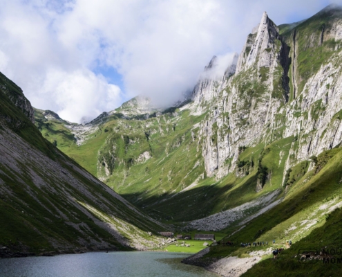 https://www.mountainmoments.com/wp-content/uploads/2021/06/Mountain-Moments-Saxer-Lucke-Fahlensee-Hiking-Route-Amazing-Photography-Lake-Main.jpeg
1335
2000
Marius
https://www.mountainmoments.com/wp-content/uploads/2023/07/MM_Logo_180-width.png
Marius2021-07-16 14:23:522021-07-16 14:24:01The Best Photo Vantage Point in Switzerland? Backpack and Discover Saxer Lucke!
https://www.mountainmoments.com/wp-content/uploads/2021/06/Mountain-Moments-Saxer-Lucke-Fahlensee-Hiking-Route-Amazing-Photography-Lake-Main.jpeg
1335
2000
Marius
https://www.mountainmoments.com/wp-content/uploads/2023/07/MM_Logo_180-width.png
Marius2021-07-16 14:23:522021-07-16 14:24:01The Best Photo Vantage Point in Switzerland? Backpack and Discover Saxer Lucke! https://www.mountainmoments.com/wp-content/uploads/2021/06/Mountain-Moments-Dolomites-Sassolungo-Gardena-Valley-Hiking-Photography-Main.jpeg
1335
2000
Marius
https://www.mountainmoments.com/wp-content/uploads/2023/07/MM_Logo_180-width.png
Marius2021-07-14 10:40:442021-07-14 10:40:51The Great Wall of Sassolungo – High-Altitude Circular Trail in the Dolomites
https://www.mountainmoments.com/wp-content/uploads/2021/06/Mountain-Moments-Dolomites-Sassolungo-Gardena-Valley-Hiking-Photography-Main.jpeg
1335
2000
Marius
https://www.mountainmoments.com/wp-content/uploads/2023/07/MM_Logo_180-width.png
Marius2021-07-14 10:40:442021-07-14 10:40:51The Great Wall of Sassolungo – High-Altitude Circular Trail in the Dolomites https://www.mountainmoments.com/wp-content/uploads/2021/06/Mountain-Moments-Lago-Carezza-Hiking-Lake-Photography-1.jpeg
1800
1202
Marius
https://www.mountainmoments.com/wp-content/uploads/2023/07/MM_Logo_180-width.png
Marius2021-07-14 09:52:002021-07-14 09:52:06Alpine Photography Realized – Lago di Carezza Family-Friendly Hike
https://www.mountainmoments.com/wp-content/uploads/2021/06/Mountain-Moments-Lago-Carezza-Hiking-Lake-Photography-1.jpeg
1800
1202
Marius
https://www.mountainmoments.com/wp-content/uploads/2023/07/MM_Logo_180-width.png
Marius2021-07-14 09:52:002021-07-14 09:52:06Alpine Photography Realized – Lago di Carezza Family-Friendly Hike https://www.mountainmoments.com/wp-content/uploads/2021/06/Mountain-Moments-Villnoss-Hiking-Map-Route-trip-photography-1.jpeg
1800
1196
Marius
https://www.mountainmoments.com/wp-content/uploads/2023/07/MM_Logo_180-width.png
Marius2021-07-13 16:07:042021-07-13 16:07:11Heavenly Hike Towards Romantic Villnöss Chappel St.Ranui (St.John) in the Heart of Dolomites
https://www.mountainmoments.com/wp-content/uploads/2021/06/Mountain-Moments-Villnoss-Hiking-Map-Route-trip-photography-1.jpeg
1800
1196
Marius
https://www.mountainmoments.com/wp-content/uploads/2023/07/MM_Logo_180-width.png
Marius2021-07-13 16:07:042021-07-13 16:07:11Heavenly Hike Towards Romantic Villnöss Chappel St.Ranui (St.John) in the Heart of Dolomites https://www.mountainmoments.com/wp-content/uploads/2021/06/Mountain-Moments-Pragser-Wildsee-Lake-Hiking-Route-Photography-Main.jpeg
1800
1440
Marius
https://www.mountainmoments.com/wp-content/uploads/2023/07/MM_Logo_180-width.png
Marius2021-07-13 16:00:092021-07-13 16:00:16Is Lago di Braies the Most Beautiful Lake in Italy? Backpack along the lake and Find Out
https://www.mountainmoments.com/wp-content/uploads/2021/06/Mountain-Moments-Pragser-Wildsee-Lake-Hiking-Route-Photography-Main.jpeg
1800
1440
Marius
https://www.mountainmoments.com/wp-content/uploads/2023/07/MM_Logo_180-width.png
Marius2021-07-13 16:00:092021-07-13 16:00:16Is Lago di Braies the Most Beautiful Lake in Italy? Backpack along the lake and Find Out https://www.mountainmoments.com/wp-content/uploads/2021/06/Mountain-Moments-Hiking-Map-Piazzo-Piatto-Platzwiese-Beautiful-Photo.jpeg
1335
2000
Marius
https://www.mountainmoments.com/wp-content/uploads/2023/07/MM_Logo_180-width.png
Marius2021-07-13 15:48:492021-07-13 15:48:55Unite With Nature on Prato Piazza Pasture in Braies Valley – We Mapped Out This Difficult Hiking Route
https://www.mountainmoments.com/wp-content/uploads/2021/06/Mountain-Moments-Hiking-Map-Piazzo-Piatto-Platzwiese-Beautiful-Photo.jpeg
1335
2000
Marius
https://www.mountainmoments.com/wp-content/uploads/2023/07/MM_Logo_180-width.png
Marius2021-07-13 15:48:492021-07-13 15:48:55Unite With Nature on Prato Piazza Pasture in Braies Valley – We Mapped Out This Difficult Hiking Route https://www.mountainmoments.com/wp-content/uploads/2021/06/Mountain-Moments-Alpe-di-Siusi-Alpine-landscape-Hiking-Route-Photography-Main.jpeg
1335
2000
Marius
https://www.mountainmoments.com/wp-content/uploads/2023/07/MM_Logo_180-width.png
Marius2021-07-13 15:25:522021-07-13 15:25:58Long and easy Hike – Backpack through Alpe di Siusi and enjoy the biggest Alpine Pasture and the famous Photo Locations
https://www.mountainmoments.com/wp-content/uploads/2021/06/Mountain-Moments-Alpe-di-Siusi-Alpine-landscape-Hiking-Route-Photography-Main.jpeg
1335
2000
Marius
https://www.mountainmoments.com/wp-content/uploads/2023/07/MM_Logo_180-width.png
Marius2021-07-13 15:25:522021-07-13 15:25:58Long and easy Hike – Backpack through Alpe di Siusi and enjoy the biggest Alpine Pasture and the famous Photo Locations https://www.mountainmoments.com/wp-content/uploads/2021/06/Mountain-Moments-Hiking-Map-Olpererhuette-Wide-Photograpy.jpeg
1333
2000
Marius
https://www.mountainmoments.com/wp-content/uploads/2023/07/MM_Logo_180-width.png
Marius2021-07-07 14:48:242021-08-28 06:53:10Hover Over Zillertal Bridge in Tyrol – Our favourite Hike Mapped Out!
https://www.mountainmoments.com/wp-content/uploads/2021/06/Mountain-Moments-Hiking-Map-Olpererhuette-Wide-Photograpy.jpeg
1333
2000
Marius
https://www.mountainmoments.com/wp-content/uploads/2023/07/MM_Logo_180-width.png
Marius2021-07-07 14:48:242021-08-28 06:53:10Hover Over Zillertal Bridge in Tyrol – Our favourite Hike Mapped Out! https://www.mountainmoments.com/wp-content/uploads/2021/06/Mountain-Moments-Hiking-Catinaccio-Rosengarten-Photography-1.jpeg
1335
2000
Marius
https://www.mountainmoments.com/wp-content/uploads/2023/07/MM_Logo_180-width.png
Marius2021-06-25 18:08:582021-06-28 11:08:24Glowing “Rose Garden” on Catinaccio Hike – Two-Day Photography Fun
https://www.mountainmoments.com/wp-content/uploads/2021/06/Mountain-Moments-Hiking-Catinaccio-Rosengarten-Photography-1.jpeg
1335
2000
Marius
https://www.mountainmoments.com/wp-content/uploads/2023/07/MM_Logo_180-width.png
Marius2021-06-25 18:08:582021-06-28 11:08:24Glowing “Rose Garden” on Catinaccio Hike – Two-Day Photography Fun https://www.mountainmoments.com/wp-content/uploads/2021/06/Mountain-Moments-Villanderer-Alm-Hiking-Route-Panorama-Dolomites-Photography-Pasture.jpeg
1335
2000
Marius
https://www.mountainmoments.com/wp-content/uploads/2023/07/MM_Logo_180-width.png
Marius2021-06-25 18:00:302021-06-25 18:11:03Villanderer Alm! Capture the Second-Largest High Alpine Pasture in South Tyrol
https://www.mountainmoments.com/wp-content/uploads/2021/06/Mountain-Moments-Villanderer-Alm-Hiking-Route-Panorama-Dolomites-Photography-Pasture.jpeg
1335
2000
Marius
https://www.mountainmoments.com/wp-content/uploads/2023/07/MM_Logo_180-width.png
Marius2021-06-25 18:00:302021-06-25 18:11:03Villanderer Alm! Capture the Second-Largest High Alpine Pasture in South Tyrol https://www.mountainmoments.com/wp-content/uploads/2021/06/Mountain-Moments-Innsbruck-Karwendel-Hiking-Route-Walk-Traik-Main.jpeg
1335
2000
Marius
https://www.mountainmoments.com/wp-content/uploads/2023/07/MM_Logo_180-width.png
Marius2021-06-24 18:32:202021-07-16 18:41:20From Innsbruck City to the Sky – Catch our favourite Picture-Perfect Karwendel View at Nordkette and Goethe-Path
https://www.mountainmoments.com/wp-content/uploads/2021/06/Mountain-Moments-Innsbruck-Karwendel-Hiking-Route-Walk-Traik-Main.jpeg
1335
2000
Marius
https://www.mountainmoments.com/wp-content/uploads/2023/07/MM_Logo_180-width.png
Marius2021-06-24 18:32:202021-07-16 18:41:20From Innsbruck City to the Sky – Catch our favourite Picture-Perfect Karwendel View at Nordkette and Goethe-Path https://www.mountainmoments.com/wp-content/uploads/2021/06/Mountain-Moments-Achensee-Barenkopf-Hiking-Lake-Achen-Austria-Main.jpeg
1333
2000
Marius
https://www.mountainmoments.com/wp-content/uploads/2023/07/MM_Logo_180-width.png
Marius2021-06-24 18:22:102021-06-25 17:33:11Pure Norway Feeling! Explore and Photograph Austria’s Lake Achen from Bärenkopf Summit
https://www.mountainmoments.com/wp-content/uploads/2021/06/Mountain-Moments-Achensee-Barenkopf-Hiking-Lake-Achen-Austria-Main.jpeg
1333
2000
Marius
https://www.mountainmoments.com/wp-content/uploads/2023/07/MM_Logo_180-width.png
Marius2021-06-24 18:22:102021-06-25 17:33:11Pure Norway Feeling! Explore and Photograph Austria’s Lake Achen from Bärenkopf Summit https://www.mountainmoments.com/wp-content/uploads/2021/06/Mountain-Moments-Zermatt-Matterhorn-Hiking-Route-Trip-Main-Amazing-Photography.jpeg
1304
2000
Marius
https://www.mountainmoments.com/wp-content/uploads/2023/07/MM_Logo_180-width.png
Marius2021-06-24 18:09:362021-06-25 17:33:23Swiss Quality Hikers Trust and Love – Instagrammable Toblerone Peak and Monte Rosa Massif above Zermatt
https://www.mountainmoments.com/wp-content/uploads/2021/06/Mountain-Moments-Zermatt-Matterhorn-Hiking-Route-Trip-Main-Amazing-Photography.jpeg
1304
2000
Marius
https://www.mountainmoments.com/wp-content/uploads/2023/07/MM_Logo_180-width.png
Marius2021-06-24 18:09:362021-06-25 17:33:23Swiss Quality Hikers Trust and Love – Instagrammable Toblerone Peak and Monte Rosa Massif above Zermatt https://www.mountainmoments.com/wp-content/uploads/2021/06/Lago-di-Sorapiss-Lake-Hiking-Trip.jpeg
1333
2000
Marius
https://www.mountainmoments.com/wp-content/uploads/2023/07/MM_Logo_180-width.png
Marius2021-06-21 09:25:362021-06-21 09:25:42Hike Along Turquoise Mountain Lake Lago di Sorapiss – Can Your Camera Catch These Colors?
https://www.mountainmoments.com/wp-content/uploads/2021/06/Lago-di-Sorapiss-Lake-Hiking-Trip.jpeg
1333
2000
Marius
https://www.mountainmoments.com/wp-content/uploads/2023/07/MM_Logo_180-width.png
Marius2021-06-21 09:25:362021-06-21 09:25:42Hike Along Turquoise Mountain Lake Lago di Sorapiss – Can Your Camera Catch These Colors? https://www.mountainmoments.com/wp-content/uploads/2021/06/Dachstein-Via-Ferrata-Hike-Mountain-Moments.jpeg
1310
2000
Marius
https://www.mountainmoments.com/wp-content/uploads/2023/07/MM_Logo_180-width.png
Marius2021-06-21 09:11:482021-06-21 09:12:25Dachstein South Face Via Ferrata for Experienced Hikers – The Great Wall of the Eastern Alps
https://www.mountainmoments.com/wp-content/uploads/2021/06/Dachstein-Via-Ferrata-Hike-Mountain-Moments.jpeg
1310
2000
Marius
https://www.mountainmoments.com/wp-content/uploads/2023/07/MM_Logo_180-width.png
Marius2021-06-21 09:11:482021-06-21 09:12:25Dachstein South Face Via Ferrata for Experienced Hikers – The Great Wall of the Eastern Alps https://www.mountainmoments.com/wp-content/uploads/2021/06/Mountain-Moments-Lago-di-Landro-Hiking-Route-Main-Photo-2.jpeg
1335
2000
Marius
https://www.mountainmoments.com/wp-content/uploads/2023/07/MM_Logo_180-width.png
Marius2021-06-19 09:11:482021-06-21 10:10:49Easy Hike at lago di Landro in the Dolomites – Overload your Instagram with Photos of Lake Dürren and Three Peaks
https://www.mountainmoments.com/wp-content/uploads/2021/06/Mountain-Moments-Lago-di-Landro-Hiking-Route-Main-Photo-2.jpeg
1335
2000
Marius
https://www.mountainmoments.com/wp-content/uploads/2023/07/MM_Logo_180-width.png
Marius2021-06-19 09:11:482021-06-21 10:10:49Easy Hike at lago di Landro in the Dolomites – Overload your Instagram with Photos of Lake Dürren and Three Peaks